Introduction
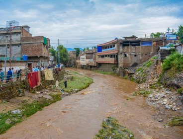
Flooding is a natural process that happens when water overflows or saturates land that is usually dry. Many low-lying, coastal areas are not only vulnerable to river flooding but also flooding from the sea. While many of these areas have systems and infrastructure in place to help mitigate the effects of flooding, managing the risk is becoming increasingly challenging. The rising frequency of extreme weather events means that floods are occurring more often, with greater intensity, and in locations that were previously less affected.
Where are the floods happening?
There are not many places on the planet without any risk of flooding. Usually, areas situated in higher altitudes away from estuaries, rivers and coastlines are considered far safer than low-lying, coastal regions. However, human settlement patterns often favour locations near waterways and coasts, as these areas provide easier access to trade, transportation, and other economic opportunities. This trend, combined with increasing urbanisation, has contributed to a higher risk of flooding in many parts of the world.
The map below shows some examples of flooding around the world in August and September 2024. The reasons vary but heavy, intense rainfall tends to be the biggest cause.
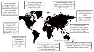
As the map shows, at the end of the summer, into autumn, seasonal changes in weather bring events such as monsoons and tropical storms, which in turn bring heavy rainfall and potential flooding.
The impact of flooding varies between locations, partly due to different levels of preparedness.
For example, hurricane season in southern US states is an annual occurrence and therefore, most people are prepared for the impacts of these storms. However, this year the intensity, trajectory and size of some of the hurricanes have meant that flooding has been felt further inland and over a wider area. Hurricane Helene is a good example; it quickly intensified from a Category 1 to 4 storm bringing vast amounts of moisture from the Gulf of Mexico and forming a 4.5m storm surge affecting coastal regions. In addition, the already saturated soil also fuelled the quantity of water being brought in by the storm. This is a phenomenon known as the ‘brown ocean effect’. As a result, over 200mm of rain fell in some parts causing rivers to burst their banks and flood lowland areas.
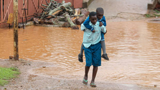
In contrast, Central and Western parts of Africa have recently received unprecedented levels of rainfall onto very dry soil increasing the threat of flash flooding by increased surface runoff and dams bursting under the volume of water. As a result, over 1000 people have been reported to have died and hundreds of thousands have been displaced. It is thought that the cause of the rainfall is the ITCZ being pushed further north that has in turn pushed wet weather fronts into regions which typically suffer from long periods of drought. Many authorities have postponed the start of the school year to late October over fears of disruption to education caused by the flooding.
Is flooding becoming more frequent?
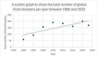
The above suggests that the frequency of global flood disasters has gradually increased from 59 in 1990 to 170 in 2023. However, this does not uniformly apply across the globe. According to a report conducted by Advancing Earth and Space Sciences (AGU) on 9th March 2021, the 20 and 50-year extreme river floods have increased in temperate areas but decreased in arid, tropical, polar and cold zones . Moreover, for 100-year extreme river flood events, there are signs of a decline in temperate and arid zones. Therefore, more frequent flood events are taking place in temperate regions than anywhere else on the Earth. Considering that this is where most people on the planet live, the pressure on these locations to help manage the impacts of flood events is significant.
Small case study: Valencia
On Tuesday, October 29, 2024, the eastern Spanish province of Valencia experienced the worst flooding in over 50 years. More than a year’s worth of rain fell in just eight hours, triggering flash floods across the region and giving people little time to escape the rising waters.
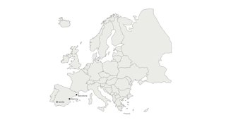
The cause of this extreme weather was an event called the ‘Dana Phenomenon’. This is created because of a pool of cold air high up in the atmosphere meeting a low-pressure system.
In this case, moisture ladened air was driven upwards by a low-pressure system from the Mediterranean and met the much colder air pool. It quickly cooled, condensed and formed an unstable environment accumulating in intense rainfall. In fact, one area received 160mm of rain in one hour.
The situation was worsened by winds meeting higher ground around Valencia, which added even more moisture to the atmosphere. Additionally, prolonged hot, dry, weather had baked the soil leaving it unable to absorb much water, leading to increased surface runoff. Over the eight hours of this weather event, 491mm of rain fell, surpassing the region’s yearly average of 460mm.
The torrential rainfall turned streets into fast-flowing rivers with a discharge strong enough to move vehicles, uproot trees, take masonry from the outside of buildings and destroy bridges. As the water rose (to three metres in places), people were forced to abandon their cars quickly and seek higher ground. An emergency alert was sent to phones of people in and around the city of Valencia at 8pm. However, by this time, flood waters had already risen quickly in some areas, giving people little time to escape.
The death toll exceeds 200 with many still unaccounted for. Rescue crews, including over 10,000 soldiers and police, were deployed by the Prime Minister to help with clean up and rescue efforts. People also came out in their droves to help with the cleanup. Villagers in places such as Sedavi were stranded as roads were blocked by mud and debris, further complicating rescue efforts.
In addition to blocked roads, railway lines and freshwater supplies were severely impacted, with high-speed rail links between Valencia and Madrid suspended. Based on similar flood events in Europe, the economic impact of this disaster is expected to be in the billions.
Possible futures and solutions
In 2022, the United Nations Environment Programme (UNEP) reported a 134% increase in flood-related disasters since 2000. In response, many organisations are developing strategies to mitigate the impact of these floods, particularly in low and middle-income countries, which are home to 89% of the world's flood-exposed population.
The economic, social and environmental costs of flooding is vast. With more extreme and unpredictable weather foreseen in the future, it is in the best interest of businesses, residents and governments to build resilience to the effects of flooding in their community. After initial research into the types and contributing factors behind flooding, authorities have taken on one, or a combination of the following approaches:
1. Investing in green infrastructure. Initiatives such as green roofs and permeable pavements can reduce absorb surface runoff lengthening the lag time into the river’s discharge.
2. Water storage and diversion systems can help ease the amount of water entering the drainage basin at one given time.
3. Flood barriers and walls to respond to flood events and protect high stakes areas.
4. Utilising of technology (e.g. mapping, prediction and protection programmes) to help with planning as well as acting as advanced warning systems to protect people.

However, these approaches should be taken in line with the wider context of the United Nations report on Valuing Water .
With over half of its land below sea level, the Netherlands offers valuable insights for other nations on managing flood risks. As climate change increases the risk of flooding as well as coastal erosion, the country’s existing infrastructure needs to be adapted to reduce the risk of flooding.
The city of Dordrecht was the focal point to meet the five Valuing Water Initiative water principles. It had a history of severe flooding and therefore was chosen as the flagship for the country’s future flood management strategy. The main prevention strategies were to limit the types of buildings in flood-prone areas, build dikes and embankments and stop logs to prevent water getting into buildings and streets. Preparation strategies focus on ensuring the safe evacuation of residents to higher ground. For instance, the district of De Staart is situated at a higher elevation and is being developed with sustainable, adaptable buildings, flexible spaces, and a transport system designed to facilitate evacuation should the population need it.
The changing climate poses increased risk of flooding from a number of sources and therefore it is imperative that people think sustainably not only about how to prevent the impacts of flooding but also the way in which we use water in the future.
Further reading
File nameFiles
File type
Size
Download
