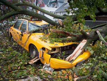
The hurricane season has arrived
According to the National Oceanic and Atmospheric Administration (NOAA), the Atlantic hurricane season spans from June 1st to November 30th. In a typical season, there are usually between 8 and 10 hurricanes, with activity peaking sharply in August. However, due to several factors, there is an 85% chance of an ‘above normal’ season in 2024.
Hurricanes (North Atlantic and Northeast Pacific Oceans), like cyclones (South Pacific and Indian Oceans) and typhoons (Northwest Pacific) are large tropical storm systems characterised by high wind speeds (exceeding 119 km/h or 74 mph) and heavy rainfall. These storms are typically 806km (500 miles) wide and 16 km (10 miles) high.
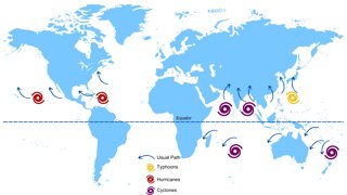
Figure 1: Tropical storm names according to their location © RGS
The National Hurricane Center (NHC) in the US name all North Atlantic storms, alternating between male and female names in alphabetical order. All letters are used except for Q, U, X, Y and Z. The names are recycled after six years, however notable storms are retired to avoid confusion in future references. The 2005 hurricane season was the most active since records began with 28 storms. After the official names were exhausted with ’Wilma‘, forecasters resorted to the Greek alphabet to name the additional storms.
How do hurricanes form?
Hurricanes need certain conditions to form. They are low pressure systems (where air rises into the atmosphere) which are fuelled by warm sea temperatures. There are five conditions needed to generate a hurricane, as follows:
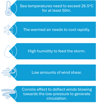
Figure 2: formation of a hurricane © RGS
There are five categories of hurricane which are determined by wind speed and identified through the .
Hurricane Beryl
This year, the Atlantic hurricane season began with an unusually strong start, marked by Hurricane Beryl making landfall in the Caribbean on Tuesday 2nd July 2024. It is the strongest hurricane to have formed this early in the season, in fact, this Category 5 Atlantic hurricane is only one of two storms of this intensity to form in July, the last being Hurricane Emily on 16th July 2005.
Hurricane Beryl's unprecedented formation and intensity set new records since weather tracking began over a century ago. Beryl originated as a tropical depression east of the Caribbean on 28th June 2024, making it the most easterly hurricane to develop in June. It strengthened to Category 4 with winds reaching 150 mph as it passed the islands of Carriacou and Petite Martinique in Grenada, destroying or severely damaging 98% of the buildings in Carriacou.
When Beryl passed over Union Island, part of the island nation of St Vincent and the Grenadines (SVG), it caused extensive devastation, with 90% of the houses either severely damaged or destroyed.
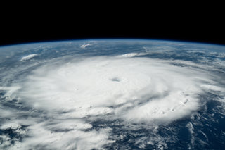
Figure 3: Satellite image of Hurricane Beryl as a category 4 storm off the coast of Grenada 1st July 2024 © NASA Johnson Flickr
Hurricane Beryl increased in strength after leaving St Vincent and the Grenadines, reaching wind speeds of 165 mph on 2nd July and was classified as a Category 5 storm – the highest category in the Saffir-Simpson Scale.
It slowed to a Category 3 storm as it passed the southern coast of the island of Jamaica with wind speeds of 195km/h (120 mph). This left approximately 400,000 people in Jamaica without power and claimed two lives. In addition, storm surges and heavy rain caused localised flooding of houses, roads and farmland with an estimated $6.4 million worth of destroyed food crops and farming infrastructure resulting in food shortages. Jamaican authorities prepared for the storm by imposing a curfew and closed main airports whilst the storm passed on Wednesday 3rd July. Nearly 1,000 Jamaicans sought refuge in shelters that evening.
The Cayman Islands were spared the full force of the Hurricane as it passed to the south, however, storm surges and heavy rainfall still affected the Islands.
Hurricane Beryl moved over Mexico’s Yucatán Peninsula as a category two storm on Friday 5th July. Although the tourist spots of Cancún and Tulum experienced heavy rain, felled trees and power shortages, no other damage was reported. Before the arrival of the storm, schools were shut, tourists evacuated (including 3,000 from Holbox Island). Over 8,000 troops from Mexico’s military were deployed to the Yucatán Peninsula to help support the area.
By 8th July, Beryl moved onto south-east Texas and Louisiana in the United States as a Category 1 storm bringing with it high winds, 38 cm of rain, and storm surges. Over 1,000 flights from Houston were cancelled with travellers encouraged to rearrange their flight plans over the following days. Ports were shut and over 2 million homes and businesses were left without power in and around the city of Houston.
This strength of hurricane has come so early in the season because of two factors: ocean heat content and La Niña. The combination of these two things could bring twice as many hurricanes this season compared to others.
As sea temperature plays a vital role in the formation of tropical storms and both 2023 and 2024 have had higher than average sea temperatures, forecasters were able to predict, with a certain degree of confidence, that 2024 would be an above-average year with more frequent and stronger storms. The sudden increase in sea temperatures over the past 18 months is still being researched, however, there is a possibility that it could be due to increased warming in the atmosphere and have a connection to climate change.
In 2023, the Atlantic region was experiencing an event. It is this event that was thought to have been part of the reason storms weren’t as abundant in 2023 even though the sea temperature was high. The increased wind shear generated in El Niño events can hamper the formation of tropical storms or reduce their intensity in the Atlantic by blowing thunderstorms away from its centre or tilting its cylindrical vortex, disrupting the ideal heat engine that usually allows storms to form.
With building evidence, scientists believe that a La Niña event could quickly follow the descending El Niño period. However, like many weather phenomenon, it is very hard to predict and the evidence is still inconclusive. A La Niña event has the opposite effect to El Niño in the Atlantic effectively increasing the chance of storms to form and build into stronger hurricanes. Therefore, if La Niña is present in the Atlantic this year, there is more chance of a larger than average storm season in the Atlantic.
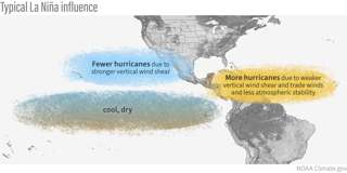
Figure 4: Effects of La Niña on hurricanes in the Northeast Pacific and North Atlantic © NOAA Climate.gov
Mitigation
This area of the Atlantic is no stranger to tropical storm events at this time of year. Many islands and their governments have strategies to protect people as much as possible. These include building resilient infrastructure, safeguarding public finances in rebuilding costs to quickly recover economies, and collaboratively working with organisations with access to forecasting software. However, these small nations, which are heavily reliant on industries such as tourism, face difficult decisions with their limited financial resources amid the increasing risk of natural disasters.
Further reading
MetMatters – What is a Hurricane? 1st February 2020
Met Office Weekly – Hurricane Beryl 2nd July 2024
In pictures: Hurricane Beryl devastates Caribbean islands, BBC 3rd July 2024 updated 4th July 2024
File nameFiles
File type
Size
Download
