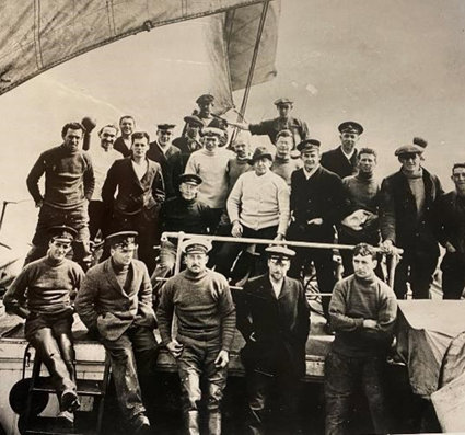
Part 1: The Expedition
These resources for primary pupils compliment the online book resource ‘Shackleton’s Endurance’ which, tells the story of Shackleton’s famous Trans- Antarctica Expedition. On this expedition, Shackleton’s ship the Endurance was lost to the ice, yet Shackleton eventually got all of her crew home without a single loss of life. The book has six sections and each is supported by a suite of teaching resources, teacher notes and ideas for assemblies.
The resources also draw on the contemporary Expedition ‘Endurance22’, sailing aboard the Agulhas II, with historian and media personality Dan Snow, which left Cape Town in February 2022 for the Weddell Sea to search for the wreck of Endurance. Through the ‘Parallel Lives’ strand, pupils can explore some of the differences between the two voyages, then and now.
There will be opportunities to dip in and sample resources from different lessons or start at the beginning and work your way through to build a coherent and longer unit of work. Ideas will be provided for both KS1 and KS2.
The Expedition
The first part of the story gives a brief background to this age of exploration in which there was competition to get to the South Pole from different countries and their explorers. It gives us the outline of Shackleton’s bold idea to try and be the first person to cross the entire continent of Antarctica on foot after being narrowly beaten to the Pole by Roald Amundsen.
Key Questions
-
What is an explorer? What do they do and why?
-
Who was Ernest Shackleton?
-
What is Antarctica? Where is it and what is it like and why?
-
When did this happen?
-
What is an expedition?
-
How do we know about this story? What evidence is there?
-
How is planning an expedition different today?
-
Where would you like to explore and why?
Getting Started
What does the very first image show? It is a cross between a map and a drawing and an aerial image, showing the Endurance in amidst the ice. Elicit some first impressions from pupils about what they think they are looking at.
On page 3, there is another map showing Antarctica and across the continent it says ‘Unexplored’. Do pupils think that must have been exciting? You can either now or later, compare the outline of this map to a current day map of Antarctica and see how accurate the outline is.
Read the first section of the book. What is an explorer? What do explorers do and what do they look like? Encourage pupils to say what they know and find out if anyone can name an explorer. Ask pupils to talk about places they have enjoyed exploring and how they felt. Or to identify places they would like to explore and why.
Explain that in at that time in history, there was a lot of competition to get to unseen and unreached places first. Exploration of remote places was especially dangerous 100 years ago, ask pupils if they can give reasons why. This might include lack of modern communications, incomplete maps, not knowing what lay ahead.
Find Antarctica on a map and establish some of the key facts about it.
Possible Activities
Antarctica
-
For Key Stage 1 pupils use globes and atlases to locate and find Antarctica. This gives an opportunity to introduce or reinforce the learning about continents and oceans, and associated language such as North and South Pole, Equator, as well as the names of the continents and oceans.
-
Using comparative maps of the Arctic and Antarctic Circles, draw out the differences and similarities, especially noting that whilst both are cold, polar regions, Antarctica is a large continent surrounded by ocean, whereas the Arctic is generally an area of ocean, surrounded by land. See the fact file for further ideas. Pupils could create Venn diagrams showing these similarities and differences.
-
Find the Weddell Sea using an atlas. Look to investigate other seas around Antarctica and their names.
-
For Key Stage 2, recap the learning about the continents, oceans and polar regions from KS1 and also hot and cold places. Use this relevant vocabulary and introduce latitude, noting the five major parallels: the Polar Circles, the Tropics and the Equator, on globes and maps. Using maps of climate zones, such as those on Digimaps www.digimapforschools.edina.ac.uk ask pupils to note the pattern of climate and latitude and discuss what other variable might influence climate – such as altitude and nearness to oceans. Using enquiry, find out significant climate and weather data for parts of Antarctica, noting its huge size.
-
For example: coldest temperature, highest wind speed, average September temperature and average March temperature. Add this information to a map.
-
Using digital maps or drawing by hand, create a map showing the route of the Endurance from London to South Georgia, marking in the places mentioned in the story, and identifying and labelling the oceans, continents, countries as appropriate. If using a programme like Digimap for Schools, pupils could measure the distances travelled on each leg of the journey.
-
Using maps and atlases, find the route described in the expedition plan. Discuss why / why not, Shackleton’s proposed plan to use the team from the Aurora to meet them halfway with supplies, was a good idea.
Explorers
-
Key Stage 1 and 2
-
Why do people explore? Ask pupils to draw an explorer and list their qualities and skills. Who can be an explorer? Challenge any misconceptions about gender and ethnicity by using some positive examples such as Barbara Hillary, the explorer who made history as the first African American woman to reach the North and South Poles, in her seventies. Or Harpreet Chandi, the first woman of colour to complete the expedition to the South Pole alone. There is a linked assembly idea with some examples of polar explorers including Shackleton. Pupils could add their own research about polar explorers and create their own list of favourites.
-
Ask pupils to write a piece about themselves as explorer and say where in the world they would go and why.
-
Discuss how we can be explorers of the everyday by finding new places, spots, views and features that you’ve not noticed before. Plan an explorer walk around the school looking for new discoveries. Take photographs, describe what you’ve found and add it to a map. Plan a mini - expedition in the locality to a place not walked to before and think about the safest route.