
Introduction
This resource looks at two winter storm events which affected the United States and parts of Canada in January and February of 2026.
January 2026 – ‘deep freeze’
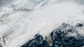
Between 22 and 30 January 2026, a Category 3 (NESIS) storm hit most of the US and parts of Canada covering nearly 3,200 km from the US-Mexico border to the eastern coast of Canada. The storm brought with it strong winds, ice and snow amongst other weather events.
The storm (unofficially called Fern) caused severe disruption over most of the US, particularly the south, which does not typically experience this type of extreme weather.
Causes
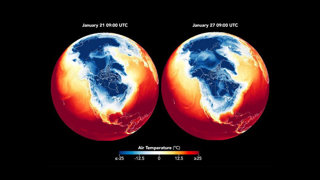
The storm was caused when the Polar Jet Stream moved further south bringing cold weather from the Polar Vortex over most of the United States. This area of low pressure met with warm moisture ladened air from the Gulf of Mexico bringing high winds, freezing temperatures and heavy precipitation.
Effects
The storm brought many different weather events to the US including:
- Temperatures fell to -3.3°C, in Vero Beach, Florida, which is extremely unusual for this region.
- 79 cm of snow was recorded at Bonito Lake, New Mexico.
- Temperatures dropped to -32°C in Alliance, Nebraska.
- Strong winds reached about 130 km/h, with gusts up to 150 km/h.
- The storm system also produced five tornadoes across the states of Alabama, Georgia, and Florida.
- Lake effect snowfall led to record snowfall in Toronto, where 56 cm of snow fell – 2 cm more than the previous record set in 1944.

The storm affected people and the environment. Some of these consequences have been summarised in the table below:
| Social | Economic | Environmental |
| Over 10,000 flights cancelled across the States with Boston Logan International Airport cancelling 60% of its flights on 29 January. | 24 US States issued declarations of emergency. | Ice storms in the south snapped trees, due to the weight of the accumulated ice. |
| Over 1 million people lost power. Most of these were in the south where an ice storm froze power lines. | Estimated $105-$115 million of damages and economic loss. (AccuWeather) | Over 40 children treated for carbon monoxide poisoning due to unsuitable heaters being used indoors. |
Figure 4: Summary of the effects from the storm © RGS.
Responses
In response to the disaster, organisations provided emergency support to affected communities. For example, the Federal Emergency Management Agency (FEMA) helped restore electricity supplies by providing generators. The American Red Cross set up around 125 warming shelters and provided emergency aid for people affected by the severe weather.
The National Aeronautics and Space Administration (NASA) also supported the response. Its Disaster Response Coordination System (DRCS) was activated on 26 January, using satellite images and data to help state and federal organisations understand the situation and coordinate their emergency response.
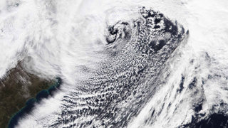
February 2026 - nor’easter
On 22–23 February 2026, the northeast coast of the US was affected by another winter storm (unofficially called storm Hernando). The storm led to Critical Weather Days between 22 and 24 February and severe weather warnings across several states in this area including New York and Massachusetts.
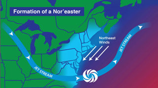
Causes
The storm was an extratropical cyclone that developed into a type of weather system known as Nor’easter. Nor’easters form when warm, moist air from the Atlantic Ocean meets the dry, cold air from Canada. These storms are common in northeastern US between September and April.
In this event, strong winds combined with heavy snowfall producing blizzard conditions across the region.
Effects
In Calvert County, Maryland, two people died when their vehicle was struck by a falling tree. Around 284,000 households and businesses in Massachusetts were left without power.
Over 7,000 flights were cancelled, and schools in affected areas were closed without remote learning on Monday 23 February. Heavy snowfall disrupted local transport, and residents were encouraged to work from home where possible.
Record snow fell in Rhode Island. The city of Providence received 83cm, breaking the previous record of 72.6cm set in February 1978.
Responses
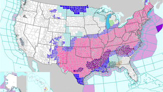
The storm placed about 40 million people under blizzard warnings, with a further 19 million under winter storm warnings. This was the first blizzard warning issued in New York for nine years. Seven states, including New York and Rhode Island issued a state of emergency.
In New York City, all streets and bridges were closed to non-essential traffic from 9.00pm on 22 February to midday on 23 February. To support recovery in New York City, 2,600 sanitation workers cleared roads using snowploughs, while an additional 1,400 snow shovelers cleared pavements and bus stops so residents could begin travelling around the city again.
Further reading
What is the Jet Stream? The Met Office
Winter storms can be deadly – here’s how to stay safe before, during and after one hits. The Conversation, 31 January 2026.
How the polar vortex and warm ocean intensified a major US winter storm. The Conversation, 24 January 2026.
How the polar vortex fuels intense winter weather in the US. BBC Earth, 23 January 2026.
Powerful winter storm slams US north-east as NYC issues travel ban. BBC, 23 February 2026.
Key terms
Lake effect snowfall - when cold, dry air passes over unfrozen lakes, it picks up warm moisture-ladened air. This air cools, condenses and falls as heavy snow bands on the downwind side of the lake.
Polar Jet Stream – core of strong winds around 8–11km above the Earth’s surface, blowing from west to east which meander around the Poles between 30° and 60° North and South.
Polar Vortex – an area of low pressure and cold air surrounding both the polar regions.
The Northeast Snowfall Impact Scale (NESIS) – a calculation which uses predicted snowfall, as well as population density, to identify the impact a snowstorm can have on society. The scale is detailed below:
| NESIS Category | Description |
| 1 | Notable |
| 2 | Significant |
| 3 | Major |
| 4 | Crippling |
| 5 | Extreme |
Critical Weather Day – an event triggered by significant weather events in the United States.
Nor’easter – a term to describe an extratropical cyclone which occurs along the northeastern coast of the US. They were named after the predominant winds which blow from the northeast in these conditions.
Extratropical cyclone – a low-pressure storm system which form in areas outside of the tropics.
Blizzard – the combination of high winds and snowfall creating limited visibility which is less than 402 metres.
File nameFiles
File type
Size
Download