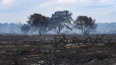
Although there is no set definition to what a wildfire is in the UK, the National Fire Chiefs Council (NFCC) has a list of criteria which help them separate wildfires from other fire types.
For it to be classified as a wildfire, one or more of the following must be met:
- Involves an area of at least one hectare (10,000 square metres)
- Has a sustained flame length of more than 1.5 metres
- Requires a committed resource of at least four fire and rescue service appliances/resources
- Requires resources to be committed for at least six hours
- Presents a serious threat to life, environment, property, and infrastructure
Wildfires in the UK in 2026
The summer of 2026 has brought unprecedented high temperatures across much of southern England and Wales leading to many counties declaring they are in drought. With the land being so dry as a result of drought, it creates a perfect environment in which wildfires can start and grow.
Up to 28 July 2026, the NFCC reported that 706 wildfires had occurred in 2026 in England and Wales, 208 of those had been between 16 and 28 July.
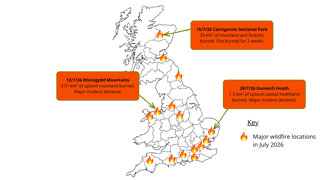
Although the total number is lower than the same time the previous year, the NFCC warn that with continued spells of dry weather, there could be a significant increase in the number of fires.
Wildfire at Dunwich Heath, Suffolk
At 5.00pm on July 29, 2026, Suffolk Fire and Rescue Service was called to a rapidly spreading wildfire at Dunwich Heath in Suffolk. The fire developed during a period of very hot, dry weather. Just a few days earlier, the area had officially been declared to be in drought because of the lack of rainfall.
Dunwich Heath is an important area of coastal heathland, most of which is owned and managed by the National Trust. Nearby is the RSPB's Minsmere Nature Reserve which was also affected by the blaze. Both are popular destinations for tourists, especially during the summer holidays and are classified as a site of specific scientific interest (SSSI) due to the diverse wildlife which lives there.
As the fire spread quickly and became more intense, Suffolk Fire and Rescue Service and the Suffolk Resilience Forum declared it a major incident. At the height of the emergency, more than 120 firefighters were working to tackle the blaze. They were supported by crews, specialist equipment and resources from seven additional fire and rescue services.
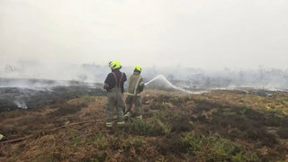
At one stage, the fire spread towards Sizewell B nuclear power station. However, there was no immediate danger to the site, and it continued to operate safely.
As a precaution, nearby homes and campsites were evacuated. People who had to leave their homes were taken to temporary shelters, where charities such as the British Red Cross provided food, drinks and accommodation. The fire also caused a power outage that affected 116 nearby properties.
With surface temperatures measuring more than 60°C and underground measuring 600°C , the wildfire caused major environmental damage. The RSPB described it as the biggest wildfire in living memory to affect the area. Valuable heathland habitats were destroyed, threatening rare species such as woodlarks, silver-studded blue butterflies and adders.
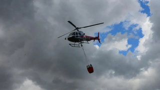
The fire produced flames reaching around six metres high in places, making it extremely difficult and dangerous to control. Aerial support such as drones and helicopters were used to help firefighters focus their efforts on the blaze as well as monitor areas which were harder to reach by land.
Firefighters worked alongside staff from the National Trust and the RSPB to stop the fire from spreading. They created firebreaks by digging trenches and turning over the soil to expose damp earth. These gaps in the vegetation helped slow the fire and prevented it from spreading into new areas. Firefighters have also used bulldozers to create 15 metre wide firebreaks.
Wildfires and climate change
Scientists believe that climate change is increasing the risk of wildfires in the UK. Warmer temperatures and longer periods of dry weather create very dry vegetation, which can catch fire easily and allow wildfires to spread rapidly.
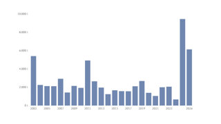
In addition to the immediate threat to habitats and people, the environmental impacts are also high. Wildfires release carbon dioxide (a greenhouse gas) and air pollutants into the atmosphere. According to Our World in Data, wildfires in the UK produced 1.4 million tonnes of CO2 into the atmosphere in 2025, the highest ever recorded in the UK surpassing the previous high of 1.18 million tonnes of CO2 recorded in 2003.
One of the pollutants of concern is called PM2.5. It is a fine particulate matter which contain chemicals that can be breathed in and lodge deep into the lungs, causing respiratory issues and damaging human health.
In response to this increasing threat, the UK Government has set aside £97m to support national resilience efforts, specifically financing wildfire response teams close to areas more at risk of these events in the future.
Sources and further reading
Wildfires, Our World in Data
Wildfires: what can the UK and other nations learn from Australia’s world‑leading fire response systems? The Conversation, July 25, 2026
Deep dive: Wildfires, heatwaves and the UK’s continuing dry spell. Met Office, July 26, 2026
Fire Emissions Watch – Live Interactive Map. Copernicus
Major incident declared after large wildfire breaks out - as UK warned of 'new normal' after drought declared. Sky News, July 31, 2026.
Why severe wildfires are becoming more frequent in the UK and how to cope with the health risks. UK Health and Security Agency, July 14, 2026
Wildfires in the UK: Understanding the Growing Risk. National Emergencies Trust
Where, why and how the South caught fire this summer? BBC, August 1, 2026
File nameFiles
File type
Size
Download
This resource was first published in August 2026.