Working with Nature: Building resilience to flood events in Pickering, Yorkshire
March 2016
The Met Office (2015) reported the wettest December on Record for Scotland (333.1 mm) and Wales (321 mm). North West England was close to record breaking rainfall. Overall, this propelled the UK into the top ten wettest years on record since 1910.
Wet, wet, wet: what caused the floods of December 2015?
In December 2015 and January 2015 the UK experienced extreme flooding as a result of Storm Desmond, Storm Eva and Storm Frank. Communities in York, Greater Manchester, Leeds and villages and towns cross the North of England were particularly affected. The Met Office (2015) reported the wettest December on Record for Scotland (333.1 mm) and Wales (321 mm). North West England was close to record breaking rainfall. Overall, this propelled the UK into the top ten wettest years on record since 1910.
Over 40,000 people were evacuated after Storm Desmond and projections by the Association of British Insurers (ABI) have estimated that claims for damage by floods so far will reach £1.3 billion. Over £24 million has been paid in emergency payments to families and businesses, 3,000 families were put into alternative accommodation. As the cost of the flood damage rose, debates began around the funding and efficacy of flood defences across the UK. The Environment Agency suggested that a “complete rethink” was needed on flood defences as the UK moves from a period of “known extremes” to “unknown extremes” (BBC, 2015). The Committee on Climate Change suggested the potential increase in extreme weather events cannot be prevented by current flood defences and the government may lack plans and policies to progress resilience to future events.
What is the economic cost of the floods? See the ABI (2016) report here.
Preparing for Climate Change in the UK via The CCC (2015). Read this report here.
See ‘Rainfall and flooding across the UK’ exploring data, graphs and maps of the heavy rainfall in December 2015 via Met Office (2016) here.
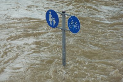
Meanwhile, it was reported the small town of Pickering, North Yorkshire, had ‘stayed dry’ through its natural flood defences and re-negotiation of policy on flooding. In our in-depth analysis of Pickering, we look at defence measures employed by Pickering and the discursive processes and community engagement through which they were designed. More broadly, this case study looks at resilience to extreme weather events, the politics of knowledge production, changes and adaptation to local weather and global climate change, and policy systems.
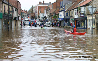
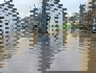
Image: Pickering under flood
Read ‘UK flooding: How a Yorkshire town worked with nature to stay dry’ (2016) in The Independent here.
Read ‘UK floods: 'Complete rethink needed' on flood defences’ via BBC (2015) here.
How does the extreme weather experienced in December 2015 link to global climatic changes? Watch Professor Adam Scaife, Head of long range forecasting at The Met Office, explain here.
The town that stayed dry?
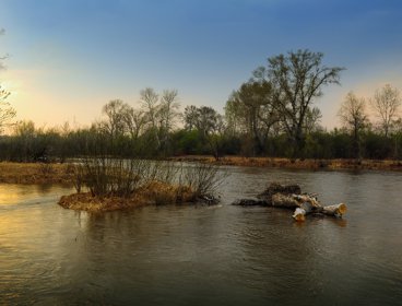
Pickering is located in the Ryedale district of North Yorkshire, on the border of the North York Moors National Park. It sits at the bottom of a steep gorge that drains the Moors. Pickering Beck is a watercourse that runs north to south through the centre of the town. At times of exceptional rainfall it is prone to flood. Changes in land management and drainage practices in this steep upland catchment have increased the risk of flash floods in Pickering and it has flooded four times between 1999 and 2007 - rain water runs rapidly off the moors and hillsides, rushing towards the town.
The Environment Agency suggested that the solution, or protection against future flood events, would be to build a £20 million concrete wall through the centre of town – this would keep the water in the river. This solution was not only deemed too expensive by the Government Treasury, but it would have impaired the landscape of Pickering and potential tourism in the area.
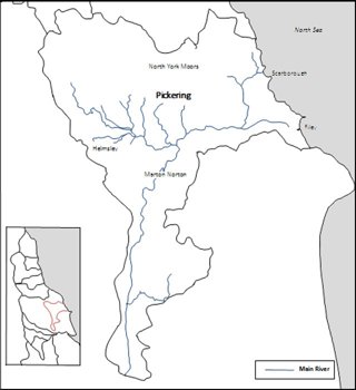
Map to show the Pickering within the River Derwent Catchment, adapted from Environment Agency report.
Read ‘Pickering flood plans on hold as costs more than double’ (2011) via BBC, here.
How has Pickering suffered from flooding in the past? Watch this clip ‘Flooding in Pickering’ (2012) of amateur footage that shows the scale and devastation caused by extreme flooding.
What is Slowing the Flow?
Slowing the Flow is a partnership project led by Forest Research, supported by Forestry Commission England, The Environment Agency, The North York Moors National Park Authority, Durham University, Natural England and the wider community. It is a new approach to flood management that plans to reduce the frequency of future flooding in Pickering whilst providing benefits to the community and local environment.
It is an approach to flood management that aims to reduce frequency of flooding by working with ‘natural’ defences. This means working with how the river occurs naturally (rather than artificially straightening the course) and working with natural materials, such as wood, leaves and debris (rather than concentrate walls). In doing so, the aim is the use these more ‘natural’ methods to store more water in the landscape thereby slowing the flow downstream. In order to achieve this, research was conducted on how floods are generated in a catchment and how land use and management affects the speed and volume of flood flows.
More specifically, Slowing the Flow aims to engage the local community through collaboration and co-production of flood risk management strategies that reflect local knowledge of the area. In doing so, the project has built natural flood defences that have social and economic benefits for the community. In doing so, the project did not just slow down flood water – but the process of decision making and flood defence design so that expert and lay opinions could be better integrated ‘slow down’.

 What are Environmental Competency Groups?
In order to work together, academics, experts, and the local community collaborated in collectives known as Environment Competency Groups (ECGs). Decisions about flood risk managements were made in these groups and in doing so, the usual notion of ‘experts’ providing solutions changed. This enabled those affected by flooding to try out alternative ways of framing the flood problem and to produce solutions that use community knowledge, and make a difference in local civic, and policy, networks.
Often, ECGs comprised of five to six project team members (made up from scientists and academics) and five to eight local members of the community. In their work on Slowing the Flow, ECGS met twice a month and often took part in activities such as fieldwork visits, video-recording and interviews with people who live and work in the area. In short, rather than traditional forms of public engagements, such as focus groups, where the emphasis is on what people think or believe about knowledge produced by ‘experts’ such as scientists, or researchers. These knowledges are co-produced with participants beyond academia – whose skills and expertise are based in locational and environmental knowledge of their community.
Want to learn more about the Environmental Competency Groups? Watch ‘Understanding Environmental Knowledge Controversies: The Case of Flooding’ (2014) here.
What are the flood defences and how do they work?
-
Construction of large woody debris (LWD) dams. Around 129 ‘leaky’ dams made up of logs and branches in the Pickering Beck Catchment.
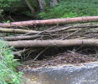
LWD dams were a common feature in most river systems, but were removed due to concerns over reduced fish moment and their potential to block bridges and culverts. However, it is thought the positive ability of dams to increase flood storage by raising water levels and reconnecting streams with their floodplain outweigh these risks.
See one of the woody debris dams in action here.
Learn more about how woody debris dams work via BBC Radio 4 podcast (2012) ‘Wood and Water’.
-
Construction of flood storage structure which can store up to 120,000 cubic meters of floodwater, releasing it slowly through a culvert.
During flood events the bund will store water and help to lower the flood peak downstream. It was designed with care to ensure that neighbouring properties, transport links and archaeology will not be adversely affected.
See time lapse of building Pickering’s flood defence here.
-
Blocking moorland drains and controlling erosion with around 187 obstructions made from heather.
Heather bale dams have been constructed within moorland drains and gullies in the Pickering Beck catchment to improve water retention and delay the generation of flood flows. Drain blocking can help to re-wet peats and slow down runoff – in addition 3.2 HA of heather habitat have been reseeded and 800m of eroding footpaths have been repaired.
-
Planting riparian and floodplain woodland. In total, around 29 hectares of woodland has been planted.
Riparian and floodplain woodland form a barrier to flood flows which helps to slow the passage of flood peak and increase upstream flood storage.
Amending forest plans and restoring streamside buffer zones farm woodland
Forest drainage systems have been redesigned to restore streamside buffer zones to help slow down runoff. During the 1960’s drains were dug in Cropton Forest to improve soil condition for tree growth; these drains led straight into streams and potentially increased the speed of runoff and the risk of erosion and siltation.
Woodland can help to protect sensitive soil from disturbance and reduce rapid runoff due to high infiltration rates – targeted replanting can help to intercept surface runoff from fields and slow down its passage to streams.
-
Implementing farm-scale measures. Roof, yard and related works undertaken on 10 farms in the Pickering Beck and River Seven catchments under Catchment Sensitive Farming (CSF).
Catchment Sensitive Farming helps to train farmers on: manure, nutrient, and pesticide management along with soil condition and farm infrastructure. Roof, yard and related works help to reduce the risk of generating rapid runoff.
Want to see how this measure works in practice? Watch this short BBC clip, ‘Slow the Flow’ (2014) that explains how the measures, such as woody dams work and woodland re-planting have been developed, the science behind them, and how they work to slow the flow in Pickering.
How reliable is flood modelling?
A monitoring programme has been established to quantify the effect of the measures in reducing flood flows. Although some of the land management interventions such as woodland creation will take time to become fully effective. Mathematical models suggest that the measures implemented in Pickering will protect the town from at least a one in 25 year flood – reducing flood risk from 25% to 4% or less in any given year. Ultimately, flood defences can only be properly measured for success during and after a flood event. Even then, it is difficult to measure with precision due to the infrequency of floods and the way they are changing with climate change. Whilst some land measurements make an immediate contribution after implementation – for example, flood storage bunds and LWD dams – others may take several years to fully develop, such as woodland planting.
In January 2016, The Telegraph reported that Pickering had “ended repeated inundation by working with nature, not against it”. Discussing the flooding in December 2015, Mike Potter, chairman of the Pickering and District Civic Society, suggested, “While there was devastation all over northern England, our newly completed defences worked a treat and our community got on with life as normal”. However, in his article featured in The Guardian (2016) Jeremy Biggs Director of the Freshwater Habitats Trust recommended we should not embrace ‘natural’ defences too hastily. Pickering, he argued, did not receive much rain over December comparative to the above average rainfall received elsewhere in Northern England. More than this, Biggs argued that ‘we need to admit that extreme events may always be beyond the control of any measures in the flood control armoury’.
See ‘Working with nature’ didn’t save Pickering from the floods – it just didn’t rain much’ (2016) in The Guardian here.
How have the measures worked so far? Watch ‘Stopping floods on the cheap: A success story from Yorkshire’ (2014) for an insight into their development – features Mike Potter, chairman of the Pickering and District Civic Society.
How can the success of Slowing the Flow be measured?
-
Economically At £2 million, the project has cost significantly less than the estimated £20 million suggested for the original concrete wall defence proposed for Pickering. It has been argued that ‘natural flood defences’ may only be cost effective to small communities who do not qualify for more expensive interventions. If these methods are used extensively and in combination, they can help to reduce impact of large flood events.
-
Politically The project has had a strong national profile and plays a role in guiding and integrating government policy on flood risk, land use management and working with natural processes. The project has helped to shape woodland planting schemes beyond Pickering - approximately 1,860 ha across England. It has also helped to shape countryside Stewardship schemes and national forest industry initiative on the role of woodland in water management.
-
Socially The local community have been engaged with the whole-catchment approach to flood risk management. Making local people ‘heard’ thus unsettling power relations between ‘experts’ and communities who live or work in their area of study. Rather, local people, academics and scientists work together to find a solution. This has been achieved through community engagement - meetings, events and volunteer support and through education and knowledge transfer – particularly through hosting site visits. Overall, this has improved local confidence and support for the land management interventions – especially when other communities in the Yorkshire region have been adversely affected by flooding as Pickering stays dry.
There has been some tension between effective placement of small flood storage bunds and the potential impact it has on protected habitats – but the participatory nature of the developing flood defences has provided opportunities for open discussion and consensus. -
Environmentally The ecosystem services provided by the different measures have been evaluated, with the most significant being climate regulation, flood regulation, habitat provision, and erosion regulation. Some of the environment benefits will be identifiable, or felt, many years from now – after flood events, and in the example of woodland – after trees have fully grown and established.
Want to read in-depth academic perspectives on Slowing the Flow? Take a look at these articles:
Doing flood risk science differently: an experiment in radical scientific method. (Transactions of the Institute of British Geographers)
Flood apprentices: an exercise in making things public (Economy and Society)
In summary
-
In December 2015 many parts of the UK, particularly Northern England, suffered from extreme flooding through increased rainfall. The damage to properties and business is estimated to be £1.3 billion.
-
Pickering located in Ryedale, Yorkshire stayed dry because of its new flood management practices under the Slowing the Flow scheme.
-
These flood management practice involve: 129 ‘leaky’ dams; construction of flood storage defence which can store up to 120,000 cubic meters of floodwater; 187 obstructions made from heather; 29 hectares of woodland has been planted; 10 farms in the Pickering Beck and River Seven catchments under Catchment Sensitive Farming.
-
Defences will protect the town from a one in 25 year flood – reducing the risk from 25% to 4% in any given year.
-
Difficult to measure success rates of flood defences without flood event and modelling of ‘natural’ defences is more difficult.
-
These flood management practices were developed in partnership between local people, academics and institutions such as Forestry Commission.
Lesson Ideas
Students can annotate a map of Pickering catchment with the measures put in place. Then, using the website links provided students can investigate the role of that each measurement plays in protecting Pickering from flooding and produce a matrix that: describes the measurement, its function in event of a flood, the positives and some negatives to its use.
Students imagine that they are part of an Environment Competency Group and adopt the role of either: academic, local business owner, local resident, environmental institution (e.g. Forestry Commission England) and research the part they played in developing Slow the Flow. Students should then take part in a mock debate with the intention of reaching a solution – in doing so understanding how ‘knowledge’ becomes co-produced. Pupils should be encouraged to support their arguments with data, facts, graphs and photographs found during their research.
Links
The Environment Agency (Pickering Factfile)
The North York Moors National Park Authority
Met Office (Climate Summaries)
Keywords
Catchment:
The action of collecting water, especially the collection of rainfall over a natural drainage area.
Culvert:
A tunnel carrying a stream or open drain under a road or railway.
Flood risk management:
Comprehensive management of flood risk for people, homes and businesses, that helps safeguard community groups from unaffordable rises in surface water drainage charges, and protects water supplies to be consumed.
Resilience:
The capacity to recover quickly from difficulties
Riparian Woodland:
A riparian zone or riparian area is the interface between land and a river or stream. Plant habitats and communities along the river margins and banks are called riparian vegetation, characterized by hydrophilic plants.
- Animation
Case study: Flooding on the Somerset Levels and Moors 2013/14
An animation exploring the social, economic and environment aspects of recovery and response
- Lecture

Flooding, climate change and the resilience of cities: Alex Nickson
- Article
Coastal surges and flooding in the UK: a prompt for more sustainable drainage?
In early January 2014, at the same time that North America was experiencing heavy snow storms and sub-zero temperatures, the UK was also facing its own package of extreme weather.