Professor Bethan Davies is a Senior Lecturer in Physical Geography at Newcastle University. At the time of interview, Bethan was a post-doctoral researcher at the Institute of Geography and Earth Sciences Aberystwyth University.
She specialises in the study of Antarctic Glaciers and at the time of interview was working on the James Ross Island Project in Antarctica. Bethan is also the author of the website AntarcticGlaciers.org which aims to promote the science of Antarctic Glaciology. This website has a new section called Hidden Landscapes of Greenland StoryMap Collection - be sure to check it out!
We spoke to Bethan about the importance of understanding Antarctic glaciers and about what it’s like to do research in the Antarctic
How did you get interested in researching the Antarctic?
My early research career (Masters and PhD) focused on the glaciation of Britain, but I have always been fascinated with Antarctica. After I finished my PhD, I got a short position at the British Antarctic Survey before starting a research position at Aberystwyth University, where I have attempted to unravel the complex history of glaciation across the Antarctic Peninsula. The romance of Antarctica, its huge relevance to society, its dramatic landscape and its rapidly changing environment are all draws for studying this enigmatic continent.
 How are Antarctic glaciers different from glaciers elsewhere in the world?
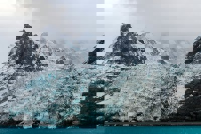
Antarctica has an infinite variety of glaciers. They range from ancient, slow moving relicts with ice that is millions of years old, to the huge Pine Island Glacier, a fast-flowing ice stream with a base that is thousands of metres below sea level. The glaciers of the Antarctic Peninsula are small mountain glaciers, fringed with ice shelves that influence and control the flow of inland ice. That is contrasted with the interior of the East Antarctic Ice Sheet, a huge arid wasteland, with ice thousands of metres thick that flows almost imperceptibly slowly.
What kinds of physical features can be seen on Antarctic glaciers?
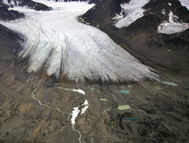
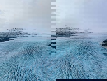
We can observe glaciers using satellite images, and map crevasses (cracks in the ice), ridges that are parallel with the ice flow, surface lakes and streams, and icebergs as they calve from the front edge of the glacier. We can also use repeated satellite imagery to track the movement of these ice features, and use this to calculate the glacier's speed. We can also use satellite data to map changes in the ice elevation; this may be because the ice is thinning, or even because a lake at the base of the ice sheet, under thousands of metres of ice, has drained. Closer to, what may appear featureless often has subtle signs of life. Small round holes may pepper the glacier's surface; they are filled with a dark sandy material called 'cryoconite', which is dust bonded together with bacteria. The wind may sculpt snow on the ice surface, forming ridges called sastrugi (which are the devil to drive a skidoo over). If it is very humid, a cold night may result in the growth of millions of tiny, beautiful frost flowers all over the ice surface.
 Why is it so important to understand Antarctic glaciers?
Antarctica has huge relevance to each one of us, through its ability to influence our atmosphere and oceans. Glaciers in Antarctica are changing rapidly, contributing to global sea level rise. We need to understand how these glaciers might melt in the future, if we are to provide policy makers with accurate sea level projections.
What kinds of changes are Antarctic glaciers experiencing?
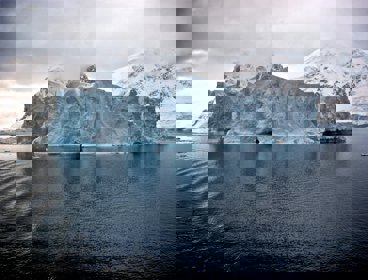
The Antarctic Peninsula is one of the most rapidly changing parts of Antarctica. Glaciers here are accelerating, thinning and receding, and are thus contributing water to sea level rise. Ice shelves that fringe the Antarctic Peninsula are collapsing. These ice shelves support the on-land glaciers; when they melt, they lose their buttressing power and the on-land glaciers accelerate and melt faster.
Further south, Pine Island Glacier is a huge ice stream in West Antarctica that is thinning, receding and accelerating. Pine Island Glacier has the potential to raise global sea levels by 1.5 m all by itself, so these changes are concerning. Even in the cold, dry East Antarctic Ice Sheet, outlet glaciers are shrinking back. The consistent picture of Antarctica as a whole is one of receding, shrinking outlet glaciers.
Can you explain a little about your research in Antarctica?
My research uses a combination of field work, where I go and map the former extent of glaciers, using satellite images to map their current behaviour, and using computer simulations to understand the relationship between glaciers and climate in Antarctica. My research aims to understand how glaciers in Antarctica responded to past climate change. I'm very interested in glacier behaviour before, during and after the Last Glacial Maximum, around 18,000 years ago, a time when the climate changed dramatically. I'm also interested in smaller glacier fluctuations during the last 10,000 years, and what this might tell us about glacier sensitivity to climate change. If we can understand how glaciers responded to large changes in climate in the past, we can put current change into context and better predict future behaviour.
For you, what are the most important things you have discovered while researching Antarctica?
So much of our exciting research is on-going, but so far one of our most significant findings has covered the birth, life and death of Prince Gustav Ice Stream around James Ross Island on the northern Antarctic Peninsula. This ice stream became active during the end of the last glaciation, around 12,000 years ago, and survived less than 6,000 years. It's one of the first studies to look at the initiation of an ice stream, and it provides important context for ice stream changes in West Antarctica today.
How do you go about researching such an extreme environment?
You have to be pretty resilient! You are very far from help and so need to be careful, as medical evacuation is challenging. But we are well looked after by a field assistant, who is a professional mountaineer and is responsible for our safety. We sleep in small tents and communicate with Rothera, the nearest British base, with radio every day. If we fail to call on the radio, they will send a plane to look for us!
It can also be pretty chilly, the coldest I've worked in is about -20°C. That's not too cold (people work in much colder environments in Antarctica), but it does mean that you have to take some special precautions! For example, drinking water must be melted from snow. Every day, you must dig fresh snow and melt it in your tent. In order to have enough water to eat and drink, the stove must be melting water pretty much the whole time you're in the tent. That does not leave much water left for washing yourself or your clothes, but fortunately nobody gets that smelly when it is so cold.
Are there any of your research methods that are particularly challenging?
They are all challenging! Each method has its own complexities and limitations. You need to be aware of these if you are to collect robust results. My computer simulations require lots of maths, which has never been a strong point of mine. Satellite image analysis requires endless hours processing data at your computer. I have always enjoyed fieldwork, but it does mean you have to put up with sharing a small tent with your colleagues for weeks on end! Used together though, these methods can provide you with exciting, original, important data.
Do you have a favourite glacier?
Davies Dome! It is a small ice dome on James Ross Island on the Antarctic Peninsula. It is not named after me though - it's named after Gwion ("Taff") Davies (1917-2005), general assistant on Operation "Tabarin"; Port Lockroy, 1944-45, and Hope Bay, 1945-46. Find out more.
Bethan was interviewed in February 2014
- Case study
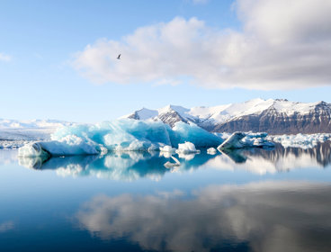
Antarctic Glaciers: Pine Island
In January 2014 new research revealed that Pine Island Glacier in Antarctica was much more susceptible to climate change and ocean variability than previously thought
- Module
Glacial landscapes
Past climate and glaciation of the Drakensberg Mountains, southern Africa
- Overview
Glaciated landscapes
Written by Dr Peter Knight and Dr Richard Waller from the School of Physical and Geographical Sciences, Keele University
- Article
Glacier recession, the carbon cycle and microbial release
How glacial systems are changing in the Alps and where glaciers are displaying negative mass balance
- Interview
Glacial change
Ulrich Kamp, Associate Professor in Geography, University of Montana, USA
- Interview
Glaciation
Dr Kathryn Adamson is a Lecturer in physical geography at Queen Mary University of London