He specialises in geomorphology, which is the study of the earth’s changing landforms, and is interested in the movement of sediment in rivers, as well as on the coast.
David’s ongoing research uses a range of sonar technologies to scan the bed of large rivers. This helps him understand fluvial sediment processes. He has recently turned these methods to focus on a personal interest: the archaeology of Dunwich, which was once one of Britain’s major economic hubs. We spoke to him about the demise of Dunwich and examine how it failed to protect itself against 1000 years of cliff retreat and now lies in ruins under the sea.
How did you come to research the relics of a Medieval town?
I used to holiday to the coast at Dunwich as a child. Back then, there were ruins of a church (All Saints) on the beach. I remember being sat on those ruins, looking out to sea. My parents told me that there was a whole medieval town underwater. I have continued to go back to Dunwich and, over the years, I began collecting resources on Dunwich that I could. As I learnt more and more about the town, it would continue to fire the imagination. So it is a real personal interest. A few years ago I had an idea that the sonar technology I use to research rivers could be used to uncover the underwater ruins at Dunwich. My first thought was: ‘I bet somebody has done that already’. But they had not. So a personal interest and a professional expertise converged very nicely.
What role can a geographer play in uncovering the archaeology of Dunwich?
As a geographer you see the spatial and temporal linkages between coastal processes, settlement geographies and broader environmental changes. A geographer would look at historic economic data, where others might not think to. For example, I have been able to date erosion events back 900 years, partly by looking at the tax returns paid to the King by Dunwich. The town asked for concessions in years when major storms had devastating economic impacts. So, as a geographer, I am able to forensically piece together many different pieces of evidence to provide a much broader understanding of the area.
What physical geography methods did you use in this research?
One of the most novel parts of this research was the technology that we used to reveal the marine archaeological heritage. The Saxon and Medieval remains of Dunwich lie just offshore in only water that is only 10 m deep. So, why on earth have more people not researched it? Well, one of the main problems is that the water is murky and the area is relatively large. The problems can be overcome with the use of sonar technology. We had three types of sonar devices, which use soundwaves to create 3D images of the underwater sediment and town remains. One of the devices we used, called a ‘DIDSON’, is like a video camera that cuts through murky waters. The hand-held device allows divers to see everything underwater. Before this technology, divers would have had to swim around the site, trying to feel the ruins with their hands and mapping them using ropes and compass bearings. This technique is difficult enough on something discrete like a shipwreck, but not if you have got a whole town covering almost two square kilometers! By using modern geographical techniques, I have been able to make huge gains in our understanding of the Medieval town of Dunwich. The techniques also helped me to research the shape of the seabed and the impact this has on rates of cliff erosion.
So, how do rates of coastal erosion vary at Dunwich?
The coastline at Dunwich changes really quite quickly. It is susceptible to erosion and sub-aerial weathering because the cliffs are made out of sands and gravels. But the rate of retreat is not constant over time. A big storm might come along and sweep away the beach, leading to a short period of intense erosion. Then, the beach comes back and erosion will slow down for a couple of years. For example, in 1911 there was a big storm. From the photos, it is clear that much of the beach was swept away. This greatly reduced the height between sea level and the cliff toe (known as ‘beach elevation’) and increased the cliffs’ susceptibility to erosion. Soon enough – by around 1913 – the beach came back. However, coastal erosion continues regardless of whether there is a beach or not. So, whilst the size and shape of the beach is important, it is not the only factor affecting rates of the cliff erosion.
Do you have any evidence of other factors affecting rates of cliff erosion?
You can trace the rate of cliff erosion back historically. For example, rates of erosion decrease rapidly from 1920 onwards. This is due to large-scale changes in the shape of the seabed. Around 1920, two underwater banks – the Dunwich bank and the Sizewell bank – both grew and joined together. This reduced the depth of the water offshore, which decreases wave height and energy. The Dunwich-Sizewell bank acted as a natural sea defence, and it still does today. In fact, the Dunwich cliffs are presently at their lowest rate of erosion and the cliff toe is relatively stable – probably in part as a result of the Dunwich-Sizewell bank. However, research shows that the Dunwich-Sizewell bank is decreasing in height. If our understanding is correct, this would suggest that cliff erosion at Dunwich will increase in the future.
Will climate change have an effect on cliff erosion at Dunwich?
Yes, but not perhaps due to rising sea levels, as many people suspect. Dunwich experienced one of its greatest rates of erosion when the climate was a lot cooler and sea levels were therefore lower. So I am beginning to think that sea levels are not much of a factor in affecting the rate of cliff erosion at this part of the coast. Climate change only alters sea level by a few centimeters over decadal timescales. So sea level rise is significant if you live on low-lying land, but the beach at Dunwich is several metres tall. Some of my colleagues are researching cliff retreat in the Isle of Wight and they have also found that over periods of up to 100 years, sea level rise is not the biggest driver of soft cliff erosion. Their findings confirm what I have hypothesised from my research in Dunwich: it is the big storms that cut back the cliffs, which are made out of weak materials. Of course the frequency of big storms is climatically driven, so climate change may well influence cliff retreat, but not perhaps by the mechanism we at first thought. Of course if sea levels rise more rapidly, and over time increase by a metre or more then this too will influence rates of cliff retreat. It is recognising the complexity of natural systems that is important to inform our understanding of past and future response to climate change.
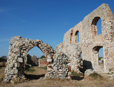
Some of the Medieval town still exists on the cliffs at Dunwich. Will this be saved?
English Heritage has responsibility for the heritage of the nation and they have a number of ‘scheduled monuments’ – nationally important monuments, given legal protection – at Dunwich. These include the Medieval Greyfriars Friary, the ‘hospital’ (as in ‘hospitality’ – essentially a posh bed and breakfast) and fragments of the last Medieval church. These are rare sites, dating back a 1000 years. Once they disappear into the sea (probably in the next 20 to 80 years), the evidence for Dunwich being a Saxon town will be lost too. Because it is not economically viable to save these monuments, I believe that English Heritage and the local archaeology trust should have a programme to investigative archaeology at Dunwich. We need to record these sites. Once they are gone, they are gone.
Looking at the history of Dunwich, is there evidence of Medieval attempts to protect the town?
Going back to the historical records, you can infer a story of Dunwich residents continuously trying to do something about coastal erosion. For example, they dug out and reinforced the harbour, which was vital to their economy. To protect the harbour, they also installed a wooden pier either side of the harbour mouth. The pier was made of wood and went out to sea, perpendicular to the coastline. It aimed to stop longshore drift, which would have formed a spit and eventually blocked the mouth of the river. A spit across the mouth of the river would have prevented high levels of river water from reaching the sea. This would only have been resolved by the river forcing its way through the gravel spit.
Unfortunately for Dunwich, this reshaped the estuary and pushed the harbour away from the town, towards the settlement of Walberswick. The people of Walberswick were delighted that the harbour was coming to them and they were able to start charging mooring fees too.
Would Dunwich have been able to protect itself using today’s coastal defence technology?
Given its status at the time, it would have been in the national interest to protect Dunwich. It was one of the UK’s top seven international ports. If you translate that forward to today, you could ask: can we protect Southampton? So, yes, Dunwich would be doing its best to protect itself and the rest of the UK would agree that it made sense to do that. The cost-benefit analysis would certainly tip in Dunwich’s favour.
Looking towards the future, what can the modern village of Dunwich do to protect itself?
The local inhabitants have come together to try out some low cost solutions – such as ‘geo-humps’. The geo-humps are large plastic geotextile bags (approximately one m2) filled with beach gravel. The idea is that they will retain sediment at the toe of the Dunwich cliffs. So far, they have worked and sediment has been retained at the cliff toe. However, the project could only afford to protect 200m of coastline. Further down the beach, where there is no defence, there has been a decrease in beach levels. So, this small intervention has had limited success. Cliff retreat looks set to continue at Dunwich and, due to the shrinking Dunwich-Sizewell bar, rates of erosion may even increase.
David was interviewed in October 2013
- Article
Coastal erosion: Britain's Atlantis and 1000 years of cliff retreat
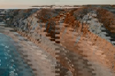
Dunwich was once one of the largest towns in England. However, the majority of the former town is now in ruins beneath the sea due to ongoing cliff retreat.
- Fieldwork
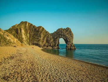
Jurassic Coast of Dorset and East Devon
The Jurassic Coast of Dorset and East Devon is a 95 mile stretch of coastline that demonstrates 185 million years of geological history
- Article
20 years, 95-miles, 185 million years: a celebration of the Jurassic Coast
A celebration of the 95-mile geological wonder