In 1910, British explorer Douglas Carruthers led an expedition through Outer Mongolia. On their way to Siberia, they saw glaciated Turgen Mountains on the horizon and adjusted their route to explore them. Carruthers eventually spent three weeks studying the regions weather, glaciers, soil, flora and fauna, and cultures.
In 2010, Dr Ulrich Kamp returned to the Turgen Mountains to follow in the Carruthers’ footsteps, almost exactly 100 years later. Ulrich is an Associate Professor of Geography at the University of Montana, USA and has an interest in changing glacial environments. He visited Mongolia to monitor the glacial change in the Turgen Mountains, using photographs from 1910 as evidence of the glaciers’ previous size and shape.
Ulrich and his colleagues also spent three weeks in the mountains, but only after two days of flying (from the USA to Europe, then from Europe to Mongolia), five days of driving (off-road for more than 10 hours a day in jeeps) and a further two days hiking (in the mountains, with horses).
What inspired you to follow in the footsteps of Douglas Carruthers’ 1910 expediton?
It was the idea of one of my students. He came to my office and said that he would like to monitor glaciers. He wanted to go into the field, climb up mountains and photograph glaciers first hand. We agreed that it would be interesting to compare present-day photographs with those taken in the past. So he did an online search for old photographs of glaciers and that is when he came across the archives at the Royal Geographical Society (with IBG), which contained photographs from Carruthers’ 1910 expedition.
Douglas Carruthers was one of the last Victorian explorers and it is amazing how much he achieved in the field. He worked for up to 14 hours a day. He wrote down all sorts of observations about all sorts of things: weather, glaciers, soil, flora, fauna, local cultures.
Standing on the same glacier that he did 100 years later, we felt a little bit small in comparison because we were very narrowly focused on just the glacier. But it just goes to show how much science has changed over the last century. Where generalists once carried out a great range of work, we now have highly specialised researchers.
How useful to you was the information that Carruthers collected in 1910?
Douglas Carruthers created a map of the Turgen Mountains on his own in just three weeks. You have to remember that he and his small team unknowingly walked into these mountains, following the path of a river towards the glaciers. Carruthers would draw and survey the landscape as he went. It was all very ad hoc, largely unplanned. But we took a copy of the map into the mountains with us and it was useful for orientation, if not all that accurate. Along with Google Earth, and other sources of mapping, it helped us orientate ourselves within the landscape.
One of the most useful (but also the most troublesome) resources to come out of the 1910 expedition was the photographs. The trouble was that Carruthers and his team never aimed to map or photograph the glaciers themselves. They photographed, sketched and surveyed the area. And they just happened to include some glaciers.
John H Miller (the expedition hunter) and Morgan Philips Price (the expedition photographer) would climb up the mountains to take photographs, but they never located the position where they took the pictures. So finding out where the original pictures were taken was a really big challenge for us, because repeat photography involves taking photos at exactly the location and from the same angle as those photos taken before.
With developments in ICT, is fieldwork still important?
Geographers today can analyse glacial change anywhere in the world without ever leaving their office. GIS allows us to remotely monitor glacial advancement or retreat using satellite imagery. However, the coordinates given to satellite imagery is not absolutely accurate.
A much higher level of accuracy can be achieved by going into the field and using GPS devices to mark the location of a glacier’s snout and edges. This information can then be compared with the satellite imagery. You find that there is often a mismatch between the two sets of data, but you know that data you personally collected in the field with a GPS device is more accurate.
There are studies that use only satellite imagery but they can draw vastly different conclusions, to the point where there are likely to be high levels of inaccuracies. It is really important to ‘ground-truth’ the secondary data that you use. We should always question the data that we are given. How accurate is it? By being in the field myself, I know exactly what I see and I can therefore make judgments about the accuracy of secondary data sources.
And is it still important to take field notes and sketches?
I could not have done any of my 25 years’ worth of research without taking any field notes or field sketches. The problem is your memory. When you come back from doing field research, you can look at photographs but, if you have no notes, it can be very difficult to remember what exactly you are looking at. Will you remember what do the photographs show, where they were taken or why you took them?
Describing the landscape in your own words is also an important skill. People can have personal feelings about landscapes and it is very important to know how they personally perceive the landscape they are researching.
Does Mongolia have an interesting landscape?
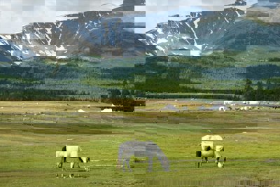
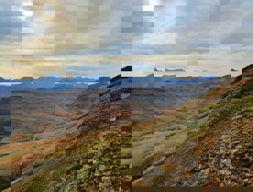
There are wide, open, vast spaces. Some people might describe this steppe landscape as ‘relatively boring’, but it has a real beauty. As you drive along, you are surrounding by green grass and relatively flat land. But everywhere on the horizon, you see mountain ranges. And the further West you go, the more mountain ranges you see.
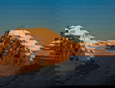
As we got close to our field site, we had to drive through areas so dry that they are defined as deserts. But we could see on the horizon the snow-covered Turgen Mountains, home to many glaciers. It is a very impressive landscape. 100 years ago, Carruthers described these beautiful peaks rising out of the green steppe and I had surprisingly similar feelings to that when I visited the area in his footsteps.
How many glaciers are there in Mongolia?
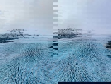
We still do not know exactly how many glaciers there are in the world. Over 100,000 have been recorded so far, but we are still counting. Mongolia has been an area of particular mystery and the first inventory of Mongolian glaciers was only released in 2013 by my research team. This complete list records a total of 670 known glaciers and glacierised areas in Mongolia, which is a lot for a very dry country. With areas of desert not far from the Turgen Mountains, the regions glaciers provide an important water source for those that live there.
Are these glaciers all retreating due to climate change?
The temperature in Mongolia has increased by 1.6°C in the last 50 years, but such warming does not always lead to rapid glacial retreat. We were surprised to find that, while many of the valley glaciers had receded, glaciers at higher altitudes were not so adversely affected.
The main Turgen icecap is located on a mountain peak at high altitudes and, when compared with pictures from 100 years ago, it showed little change in ice coverage. GIS analysis confirmed that the icecap had receded by only 1.5%. It was almost intact, even after 100 years of global warming. The fact that you find glacial change at mostly lower elevations is also true for many other locations worldwide. So we have to understand that cold landscapes are highly differentiated and must be analysed at a range of scales.
There are actually many advancing glaciers in the world, a number of which can be found in Karakoram Mountains. The Karakoram Mountains are home to K2 (the world’s second highest peak) and cover the border region between China, India and Pakistan. In this case, global warming has increased rates of evapouration, particularly in the Mediterranean Sea, resulting in higher levels of cloud cover and delivering more precipitation to the Karakoram . During the winter, and at high altitudes, this precipitation falls as snow. So, ironically many Karakoram glaciers are actually advancing as a result of global warming.
Do you expect people to return to the Turgen Mountains to repeat your research, just as you repeated the 1910 expedition?
That would be a dream! We have now produced an inventory of photographs, including the location and angles from which they were taken. All of this is available in the Geographical Journal which is the same journal that Carruthers published his original expedition findings in.
Using the information that is available, anyone can repeat our research. It would now be fairly straightforward to take repeat photographs to monitor glacial change in the Turgen Mountains. Students are welcome to contact me if they want to do so. Hopefully people will not wait 100 years to repeat the study this time – 10 years would be long enough!
Ulrich was interviewed in July 2013
- Case study
Glacial retreat: Historical evidence of climate change in Mongolia
This research analyses glacial retreat in the Turgen Mountains, northwestern Mongolia.
- Interview
Glaciation
Dr Kathryn Adamson is a Lecturer in physical geography at Queen Mary University of London
- Module
Glacial landscapes
Past climate and glaciation of the Drakensberg Mountains, southern Africa