How did trade get global?
In the first lesson of the module, pupils are given a clear definition of trade: ‘the buying and selling of goods and services we want and need’. They consider whether they could live without exchanging goods and services. Pupils gain an understanding of the geographical concept of scale, and track how the scale at which trade can be carried out on has increased through time, from local to global. They learn trade now links people in locations all over the world. Pupils explore what developments have enabled trade to be carried out on a global scale, focusing on improved technology, transport, and communications. The main activity involves creating a trade timeline which compares the scale of trade at three different time periods (The Stone Age, 17th Century and 21st Century).
Food and global trade
In this lesson, pupils are encouraged to consider where food comes from. They use maps and atlases to locate the source of a range of popular food products from a typical shopping list. The terms ‘import’ and ‘export’ are introduced and pupils learn that the natural resources available, land mass, and climate of a country determine what types of food they export and import. Pupils discover that global trade enables us to have access to many foods that cannot be obtained within the national borders of the UK. The class is encouraged to consider the journey their food takes from source to sale in the main activity by labelling the source locations of food products on a blank world map and drawing the trade link to the UK.
The global supply chain
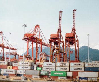
As the unit develops and pupils gain a greater understanding of trade and its global scale, they are introduced to the multi-step journey of complex manufactured goods and the global supply chain they go through from source to sale. The definition of global supply chain is given to pupils ‘the journey travelled by clothing, food items and other products through different factories, suppliers and warehouses before ending up as the finished product we buy in shops’. They explore the three broad stages of the global supply chain: primary, secondary and tertiary and learn what job roles and activities belong to each. Pupils focus on the case study example of cotton clothing and the multi-stop journey cotton goes on as it is transformed into clothing items. The main activity involves applying their knowledge of the primary, secondary and tertiary stages of the supply chain of this case study example.
What does the UK export and to where?
In this lesson, the class examines global trade from a different perspective: what the UK exports to other countries and which countries the UK exports the most to. This lesson is cross-curricular with the KS2 mathematics national curriculum data handling objectives and involves interpreting and creating graphs to show data related to UK exports in the system of global trade. The idea of a pattern of global trade: that more developed countries export valuable manufactured goods and import less valuable, primary products is introduced to pupils. The pupils consider the geographical reasons behind this pattern, mainly related to human geography and how developed the country is. The main activity involves creating a bar chart to show the top 10 products exported by the UK and money made from each of these exports. Pupils assess whether these are complex manufactured or primary products and raw materials.
Investigating fairtrade
In this lesson pupils question the fairness of global trade and are introduced to the idea of global citizenship: our actions impacting others in other locations around the world. The benefits of fair global trade are explained and pupils learn how those living in less developed countries can help themselves out of poverty through their work with fairtrade organisations. Pupils compare the prices of fair and non-fair trade products and discover why it is that fairtrade products can cost a little more. They discover where the additional cost goes (supporting communities of producers and manufacturers ensuring good working conditions and fair wages). The class explores the Fairtrade Foundation website to discover what products you can buy fairtrade and look at the website’s interactive map to find the location of fairtrade producers. The main activity involves creating a poster outlining the reasons why consumers should pay more for fairtrade goods.
Highest-valued exports
The final lesson of the unit teaches pupils the term and concept of ‘highest-valued exports’. The pupils learn that the highest-valued export of a country is the good that makes the country the most money through global trade. Thinking geographically, pupils consider physical and human features of each country that determine what type of export makes that country the most money. Case studies of the highest-value export of the more developed USA and less developed Liberia give pupils an in depth understanding of how it is both physical and human geography of a country that determines this (climate, resources, skills, technology, and communication systems). The main activity involves using online maps to match the highest-value export to country names found in an atlas or digital map. The pupils research the physical and human features of each country to discover the reasons behind the highest-valued export. The module ends with a Fairtrade Tea Party celebration of learning and discussion of global trade. Pupils are encouraged to share their personal opinions on global trade, and enjoy the fair trade snacks they brought in. An end of unit assessment is also included as part of lesson six.
About the author
Olivia Russell studied human geography at the University of Leeds and specialised in geopolitics, sustainability, and international development. After graduating, she completed a PGCE in primary education with the subject specialism of geography. For her specialism project she researched young children’s representations of their local area and most meaningful places through map making. Olivia went on to teach at a primary school in the London borough of Islington and was subject leader for geography. She worked in the Education Department at the Royal Geographical Society (with IBG) on the Rediscovering London’s Geography project.