
Hazards and Volcanic Gas Emissions
On 3 June 2018, Guatemala’s Fuego volcano erupted. It is the strongest eruption in 44 years. The volcano set off lahars – fast flowing mixtures of rock, debris, ash and water – which buried nearby villages. Guatemala is the biggest economy in Central America. Yet, according to World Bank, it has one of the highest inequality rates in Latin America. Poverty, malnutrition and maternal-child mortality rates in rural and indigenous regions. Of all the people living in poverty, 52% are indigenous.
You can read more about the Summer 2018 volcanic activity here:
GUATEMALA VOLCANO AFTERMATH - IN PICTURES (BBC, 2018)
GUATEMALA'S FUEGO VOLCANO DISASTER: LATEST UPDATES (Al Jazeera, 2018)
THE DEADLY ERUPTION OF A GUATEMALAN VOLCANO (The Economist, 2018)
Only a few weeks previously, Hawaii’s Kilauea volcano erupted on 4 May, and in Indonesia Mount Merapi volcano has been erupting since mid-May. What drives such activity? Given that they often impact communities locally, national and internally it is important that volcanoes are monitored. Volcanic gas emissions are the driver of the vast majority of volcanic activities. In this podcast Dr Tom Pering from the Department of Geography, University of Sheffield discusses his research into using smartphone technology as a research tool to monitor these gazes and expand how geographers engage with hazards. You can follow Dr Pering’s research on Twitter.
Learning activities
Listen to the podcast and answer the following questions
-
Why is it important to know baseline gas emissions of volcanoes?
-
How have volcanic gases been measured
-
How have scientists changed how they monitor gas emissions?
-
What is remote sensing?
-
What is the correlation spectrometer?
-
What are the social and economic restrictions to monitoring volcanoes?
Dr Tom Pering is currently researching Massay volcano, Nicaragua. It is a complex volcano that is composed of a nested set of calderas and crates – the largest. Watch this vlog by Dr Tom Pering, and describe the features showcased and distinctive hazards generated. You can read about this research on Dr Pering's blog.
What is it like to live with volcanic gases? This video explores life near the Massay volcano in Nicaragua. Watch the film take notes on how the community builds lives in this hazardous landscape. How have they adapted and build resilience? What are the risks? Consider your answers in relation to the economy, health, infrastructure, food and water security, and social life
If time permits, read the following articles and produce notes to produce a full case study of the Massay volcano.
VOLCANO EXPERT AND GUIDE SURVIVE FALLING INTO ACTIVE NICARAGUAN CRATER (The Independent, 2018)
EXPLORING NICARAGUA’S VOLCANOES IN A CLOUD OF ASH (The Independent, 2015)
RASPBERRY PI AS A LOW-COST METHOD THAT WILL SUPPORT DEVELOPING COUNTRIES (Volcano Blog, 2016)
THIS ACTIVE VOLCANO IS BEING CONNECTED TO THE INTERNET FOR A LIFE-SAVING REASON (Huffington Post, 2016)
Key words
Quiescent
A volcano, which is not active, but is still registering seismic activity
Remote sensing
The process of detecting and monitoring the physical characteristics of an area by measuring its reflected and emitted radiation at a distance from the targeted area
Volcanic gas plume
A column of hot volcanic ash and gas emitted into the atmosphere during an explosive volcanic eruption
Raspberry Pi
A low cost credit-card sized computer that can be used in electronic projects, and many things that desktop PCs do.
- Interview

Volcanoes and volcanology
Sarah Henton, graduate student, Alaska Volcano Observatory, Geophysical Institute, University of Alaska, Fairbanks
- Case study
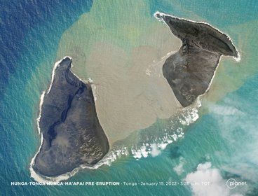
The Hunga Tonga-Hunga Ha'apai 2022 volcanic eruption
In January 2022 the Hunga Tonga-Hunga Ha'apai volcano erupted in the Pacific Ocean
- Lecture
A cooling Earth: monitoring its hazards - Associate Professor Dr Matthew Blackett
School Member Lecture, 28 September 2022