Ideas for on-site school fieldwork
We asked our group of Geography Scholar Trainee Teachers for their ideas for school-centred and local fieldwork during the COVID-19 Pandemic. Here's what they suggested...
Mobile phone reception mapping
Encourage your students to explore the school grounds by giving them an aerial map of the site. Students are grouped with people using different mobile networks. The task is to go around the school marking level 1, 2 or 3 depending on the reception signal of their phones. This can then be mapped and colour-coded back in the classroom. A great little form of data collection — and one that arises much consternation!
SurveyMonkey
This is an example of human geography and virtual data collection. Students use SurveyMonkey website to devise online surveys to send out to teachers and parents. Data collection from the comfort of your own home! It is a skill that's used heavily in undergraduate dissertations so this activity acts to bridge the gap between A-Level and university geography.
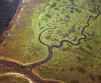
Rivers
A really successful example of fluvial fieldwork on two contrasting rivers, whereby students compare two river systems by putting data tables side by side. Key information about river velocity, depth, width and water quality. Information on a selection of invertebrates (as close to life size as possible!) e.g. stonefly larvae, rat-tailed maggots etc. is then downloaded and read. Students need to use the ID sheets to ID the insects, and then determine which water quality would best suit them. The activity can be done in teams. The first group who puts all the invertebrates in the correct river 'wins' the game. It's a bit of a competition to get the students passionate about the natural world with the added bonus of some fundamental data collection skills, when they're finally allowed out (there is scope to extended the activity by calculating the area and discharge of each river). There's some great help on River fieldwork techniques on the RGS-IBG website under Fieldwork resources.
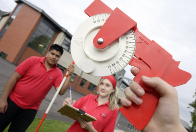
A microclimate investigation
This requires students to visit various sites outside of the school grounds e.g. outside main building, sports courts, car park etc. or it can be set as an extended remote learning project. The task is for students to take measurements of different elements e.g. temperature, wind direction, air pressure and rainfall however no equipment is provided. Students are given advice and directed to the RGS-IBG website to make their own thermometer, weather vane, barometer and rain gauge. Students can then use results for data presentation skills e.g. graphs, working out ranges and averages.
Emotional mapping
Students walk around their local area, making sure to visit different locations on the map. When they move through forested green spaces or walk across polluted busy roads or find themselves in a quiet park they then collect qualitative data on how their feel about the location, this could be as simple as drawing either :) :/ :( at the same time get the students to write down a few words to describe each location.
Campus based fieldwork
One I have used for several groups during Covid restrictions is a campus based field work. Students are given several plausible sites around the school grounds to erect a wind turbine as part of the schools move towards being carbon neutral. Students take measurements of height, wind speed and prevailing wind direction over several sessions. Data is collected. In addition GIS is used to map the proposed locations including proximity to school buildings, local housing and impacts on the natural environment, etc. Data should be acquired in advance by the teacher on sound levels of the turbine, height, etc.
Google cardboard VR
This is a classroom based activity using Google cardboard virtual reality goggles and Google Expeditions. You can experience virtual reality in a simple and affordable way. Using the VR goggles (for as little as £7) students can roam the world, such as exploring Mount Everest. While investigating the different scenes from Basecamp to the summit students have to answer various questions about the physical geography and the challenges of climbing Earth's highest mountain (above sea level).
A coastal classroom
Students throw covers (borrowed from the drama department) over desks to create the varied topography of coastal sand dunes. Ideally the covers will change colour from yellow to a darker grey to represent the increasing humus and bacteria. This would give students the opportunity to practice their cross-sectional drawing of the classroom, as the spaces between desk rows would represent dune slacks. Going a step further, any student rucksacks that are green could be placed on the last mature dune to mark climax vegetation! A3 labels are then stuck onto the different parts of the classroom model. This can be followed up with a lesson on coastal processes and management ideas from the Jurassic coast.
Use a Go-Pro
I went to Iceland in February and took Go-Pro footage snorkeling in the Silfra Fissure, between the Eurasian and North American plates. From this, I created a Virtual Field Trip where students saw it as I saw it. Firstly, they visited the location via Goolge Earth and then took a 'virtual swim' in the fissure with the Go-Pro footage. I managed to source some measurements and from this, students were able to plot the long profile of the fissure every 10m. They were then able to use this along with photos to identify the main sections of the fissure. Map work and revision on types of plate boundary are also incorporated as you might expect. Alternatively, visit Youtube - (teachers and students can earn a 'Digital Badge' for 3D mapping).
Mapping sense of place
Students draw a map of their local area from memory, then compare it to an OS map. What did they include or emphasise in their map? What did they miss out? Does this connect to how important places are for them? This idea could be expanded with Place profiling.
Virtual fieldwork
I have created a virtual fieldwork trip to a section of the Jurassic coast using ArcGIS. The fieldwork starts with identifying where the erosional landforms will be and how long it would take to get there from the school of origin. I think this promotes locational knowledge and helps with engagement. The students then learn about each landform by using interactive activities and videos on the website and fill in a worksheet in order to keep a record of their learning. The map is interactive as well so students can 'explore the area'. To create something similar use the Getting Started with 3D map with ArcGIS online beginner's guide.
Gloucester
The Gloucester city centre is currently in the middle of being massively invested in and transformed into new urban spaces for both retail and pleasure and it is interesting to see how these designs are contrasting against the historical backdrop especially around the cathedral. Land use change over time is quite considerable; King's Square was once a bus station come market space before being made over to gardens and fountains, and is now being transformed yet again. The area around Brunswick Road in the city is also worth a visit as there are new high-spec residential developments that have replaced the former city centre college and has created a surge in people wanting to live in the middle of town. A complete antidote to the age old Burgess Model. Hop over the bridge taking you across the River Severn and you are immediately on flood plains with all the features of Britain's longest river at your fingertips!
Sampling
The importance of teaching sampling methods, from an early age, cannot be overstated enough. Around the school site students can use a quadrat and either random or stratified sampling to look at vegetation type and cover (this is also a nice cross-curricular link with biology). There is help on sampling techniques on the RGS-IBG website. Students could then do some analysis on the results using charts.
Urbanisation and rural-urban migration
This is a fieldwork activity that uses historical and more recent census data to establish rural vs urban populations through time. Could be compared to the stages of the DTM, HDI and overall population of the country. The students could then use statistical analysis to explore the validity of any conclusions and to project future migration patterns in a variety of countries.
GCSE rivers
In lieu of fieldwork trips in 2021, myself and another member of staff decided to go to the fieldwork location ourselves in order to record videos of some of the skills/activities involved. The main aim of this was to give some context to the rivers section of the syllabus, and to demonstrate some of the skills students may be asked about in the Geographical Skills: Paper 3 exam. The demonstration included analysis of sediment size, river channel width measuring, river depth measuring and so on.
Infiltration enquiry
An infiltration enquiry is a good way to expose KS3 students to GCSE fieldwork, particularly as all major elements of the enquiry can be done in the classroom. Students can then be taken outside on the school grounds with equipment to learn how to measure this. If students are remote learning at home they can build their own equipment. Students can then be given homework to collect data safely in various places around their home or local community. Once data is brought back the final elements of analysis, conclusion and evaluation can be undertaken.
Ethical fieldwork
How can we do geography fieldwork more ethically? Secondary school geography tends to construct fieldwork sites as static, contextual settings for investigating certain human and physical geographic processes. Students could think about their positionality, ethic of care, and responsibility as geographers towards the places they are investigating. Consider if this an opportunity to broaden our students’ conceptualization of place? Here, we could draw explicitly upon geography’s three leading conceptualizations of place: place understood through cultural and subjective meanings and identities; place as emergent and always becoming; and a ‘global sense of place’ understood by looking outwards through connections to other places.
Ecosystem study
Ask students to take pictures of any birds, insects, mammals and plants they see in an outdoor location. Using the Ecosystem Starter Resource students initially learn the difference between abiotic and biotic and then progress onto identifying their species online using an ID sheet. As an extension task students are asked to make a food chain or simple food web for their school or back garden.
Soil compaction
Student use different surfaces around the school or in the back garden at home to measure infiltration rates. Once data is collected on three different surfaces a discussion about the influencing factors can be initiated. A follow up experiment might be included on the impact of soil compaction, which only requires equipment that can be made at home. For both these experiments students will only need a bottle, water, a timer, a knitting needle and 30cm ruler.
Holderness
After teaching students about the rapidly eroding Holderness coastline they are set the task of creating a double page fieldwork map identifying Hull, Spurn Head, Withernsea, Mappleton and Flamborough Head. There is a great ESRI education map with 5 buttons at the foot of the screen for Global view, UK overview, 2D, 3D and Historic view of the Eastington gas terminal which allows students to zoom in and explore.
- Fieldwork
Field recording for school data collection
Audio recordings are an excellent form of data collection
- Fieldwork
School grounds ecosystems study
This module has been designed to enable students to learn and practice a variety of fieldwork techniques in their school grounds
- Fieldwork

School grounds fieldwork
Ideas for quick and easy fieldwork in your School Grounds