The conflict in Ukraine has led to severe disruption to higher education, both as a result of physical damage to facilities and through the displacement of staff and students. Virtual fieldtrips (VFT) have been used to support geography students at V. N. Karazin Kharkiv National University (KKNU) in the east of Ukraine. Through a series of online workshops, students learnt how to use ThingLink, an online tool used to create interactive media, to produce their own VFT using photos from previous fieldtrips, maps, images and external web-based sources. Find out more about this work in this article on Geography Directions.
We spoke to three students who told us about themselves and their VFT:
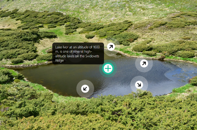
Lake Ivor VFT, created by Ilona Kostyrenko
"I am a second year student on the study programme Cartography, Geoinformatics and Cadastre. I became interested in geography in school, where first it was a subject called ‘I explore the world’, then geography. I have always associated this subject with nature, and since I grew up in a village there were always boundless horizons around me. Later, the question of choosing a university was difficult, but my choice fell to my true passion and the study program at KKNU. One of its special features is the combination of geography with modern GIS technologies.
"The topic of my VFT is related to my school’s second year student field trip in the Carpathians. In the first photo, you can see students near the picturesque Lake Ivor and its surroundings. My VFT primarily uses ThingLink and Google maps resources. Currently, due to hostilities, I am in a small village where there is nothing interesting to demonstrate in a virtual tour. But we are indomitable people and can find a way out of any situation. Therefore, I used the photos of the Carpathian landscape from fieldwork the previous year. Having been distance learning for several years now, I can say that studying online is difficult, but quite possible."

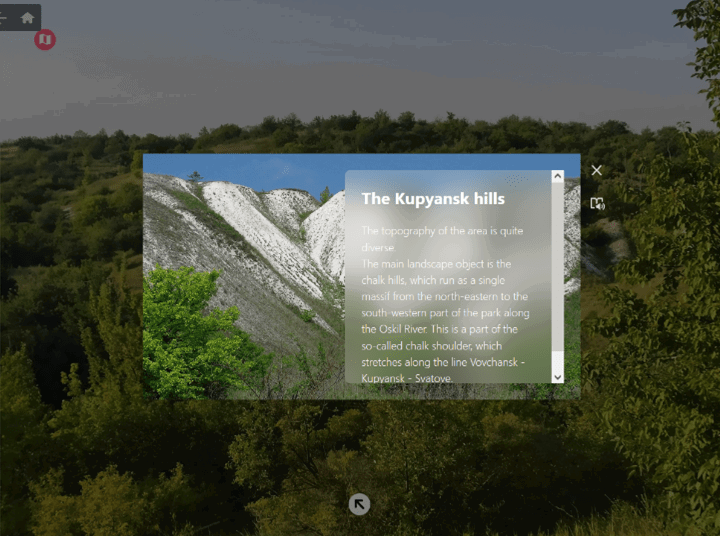
Chalk hills VFT, created by Sophia Ivanenko
"I am a third year student on the study programme Geography of Recreation and Tourism. I like my speciality because of the opportunities for international study exchanges, as well as because of the in-depth program of studying aspects of recreation and tourism around the world. I never dreamed of becoming a geographer and studying at KKNU, but I have always wanted to be a part of something big and important. My life is already inevitably connected with travels and adventures, because now I am a part of the small public organisation Ukrainian Union of Young Geographers, as well as the Kharkiv branch of European Geography Association for students.
"My VFT is devoted to the study of the natural features of the Kupyansk district of the Kharkiv region. In summer 2021, I went on a short daytrip to the chalk hills. The area really impressed me with its geomorphological features (in particular, fossil belemnites). Now this VFT gives me warm memories of that summer trip, which, unfortunately, cannot be repeated in the nearest future. From February to September 2022, the Kupyansk district was under occupation, therefore, a huge area of this part of the Kharkiv region is currently mined."

My little homeland VFT, created by Polina Dovzhenko
"I am a fourth year student on the study programme Geography of Recreation and Tourism. In my opinion, the fact that I was born in a village greatly influenced my future study choice. I’ve always been close to nature and over time I wanted to explore it more and more. I also like to travel and getting to know new places. That’s why I’m a student geographer now. And I really like the involvement of the latest technologies, such as VFT, in our educational process.
"My VFT is dedicated to various natural aspects of the area where I was born and raised. I decided to choose this topic because, in my opinion, the area is quite interesting. Besides, I know this place very well and have a lot of materials (photos and audio) that I used for this project. I’m interested in researching the flora and fauna of the area, so I’ve included links to iNaturalist and the website of the Ukrainian Red Book to some of my photos of plants/mushrooms/animals to provide information about these species. I also added a link to the geological map of Ukraine and the Google map of this area. In my case working remotely was easy because I had all the resources I needed."

Student experiences
The organisers of the workshops collected student feedback and found that most students enjoyed the experience of creating their own VFTs. Some of the students used their VFTs as a way of revisiting past in-person and pre-war fieldwork, whilst others approached this from a technical perspective exploring the different methods and ideas using the ThingLink platform.
However, some students had difficulties accessing and producing online content, particularly those in the occupied areas of Ukraine where internet access is limited.
How to create a similar VFT
The VFTs were created using ThingLink, an established educational platform for visualisation. ThingLink is available for free with some restrictions, and there are discounted educational licences.
