Resolving conflict between protected species and infrastructure development
After demonstrating that traditional approaches to reduce development impacts on newts often fail, the research team developed a new approach combining eDNA surveys for newts with ‘risk map’ modelling. The approach has been adopted by Defra/Natural England, leading to a new landscape-level approach for mitigation that combines eDNA data and modelling.
Issue
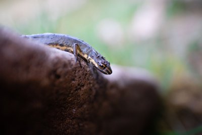
The great crested newt has been declining across its European range and receives full legal protection in the UK. However, the widespread distribution of the species means that it frequently comes into conflict with infrastructure development. In a speech on 30 June 2020, the Prime Minister declared that ‘Newt counting delays are a massive drag on the prosperity of this country’.
Approach
The research team combined field surveys with systematic evidence review and analysis of unpublished post-development reports. This was followed by further research in partnership with Amphibian and Reptile Conservation, commissioned by Defra and Natural England, analysing the impact of traditional actions to mitigate development impacts on great crested newts.
Recent advances in DNA technology have enabled the detection of species through the DNA that has been shed into the environment, known as environmental or eDNA. In collaboration with partner organisations the team have taken the lead in developing and validating the technique to assess the distribution of great crested newts.
Impact
The new methodologies devised by researchers at the University of Kent and the team at the Durrell Institute of Conservation and Ecology (DICE) have revolutionised the way in which great crested newt sites are assessed, and shifted mitigation measures away from inefficient site-based protocols to a landscape-level approach. This work has led directly to changes in government policy at national level (Defra, Natural England), and acted as a catalyst for innovation and new business creation.
The work is used as the basis of District Level Licencing schemes, which use ‘risk maps’ for great crested newts based on the team’s methodology of combining large-scale eDNA surveys with species distribution modelling. District Level Licensing has resulted in the creation or restoration of 386 ponds to compensate for potential development impacts.
A series of workshops relating to the use of environmental DNA have resulted in over 300 practitioners who are now better-equipped to deliver and interpret the results of the eDNA-based surveys.
More information
Institution: University of Kent
Researchers: Professor Richard Griffiths, Dr Joseph Tzanopoulos, Dr Dimitrios Bormpoudakis, Professor Jim Groombridge, Dr Andrew Buxton
Share this resource
This is an open access article under the terms of the Creative Commons Attribution License (CC BY NC 4.0), which permits use, adaptation, distribution and reproduction in any medium or format, provided the original work is cited and it is for non-commercial purposes. Please contact us for other uses.
How to cite
Royal Geographical Society (with IBG) (2023) Advancing new assessment and mitigation approaches to resolve conflict between protected species and infrastructure development in the UK. Available at https://rgs.org/resolvingconflict Last accessed on: <date>