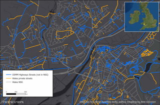
GeoPlace created this visualisation, which was commissioned by the Welsh government, showing the network of unadopted roads in Wales. Here the GeoPlace team discuss why it was created, the data and techniques that were used and the impact it has had.
Explainer
What story does this visualisation tell?
Unadopted roads have been a long-standing issue for the Welsh government and councils since there is no meaningful data readily available on them and the only information that appears to exist is from 1972. Privately owned, these highways are not maintainable at public expense, and it is difficult to quantify their extent, especially if they’ve not been brought under the wing of a local council. As such, government and councils are keen to address unadopted roads and their potential impact to residents and the public. One issue identified in a 2019 report to the Welsh Minister for Economy and Transport was: ‘There is currently little reliable, managed information available, and it is difficult therefore to quantify the extent of unadopted roads, and the cost of remediation’.
By undertaking primary research via a consultation exercise on behalf of the Welsh Assembly, we (the GeoPlace Team) identified 148,006 streets with a total length of 19,635 from the OS MasterMap (OSMM) Highways Network.
Why was it created?
A task force was set up in 2018 at the request of the Welsh Minister for Economy and Transport to see what could be done to bring specific unadopted roads to a consistent adoptable standard. Even though there is no consistent method in which Welsh unadopted roads are collected and recorded, identifying and using local government data was vital to build a suitable picture of unadopted roads in the country.
The visualisation is eye-catching not only because it distils and simplifies a complex idea, but also because it represents the depth of information we collated to support the creation of a consistent dataset. We used spatial matching techniques to extract all the roads which hadn’t been included by Welsh local authorities and this innovative approach led to us providing a complete picture of the unadopted streets network to the Welsh government.
Ultimately, the map serves as a vivid reminder that no one dataset is suitable alone and using various datasets from different sources can help provide a reliable representation.
Who was the intended audience?
First and foremost, the Welsh Government, in order to provide detail on the various data which was used to instil confidence in the process that we took and the results we provided. Moreover, it was intended for this story to raise awareness around the long-standing issue of unadopted roads in Wales for anyone who is interested. That is why we wanted the map to have a clear style and provide data in an accessible format for those who are concerned with the effects that these streets can have. This includes local authorities, representatives of housing developers and members of the public who may be curious about this subject matter.
What data and techniques were used to create it and why?
We used a range of spatial matching techniques and datasets. First, we identified all the streets that we could either be certain were unadopted or were yet to be included by Welsh local authorities and therefore could be unadopted.
The visualisation shows how the process began with the Local Street Gazetteer (a local authority-maintained dataset) as the underlying network, overlayed with the OSMM Highways Network. We were then able to build on this information and identify additional streets that could provide a full indication of unadopted streets.
We used AddressBase to identify how many properties existed against these streets. To ensure the most accurate results, we used the Unique Street Reference Number (USRN) from the National Street Gazetteer (NSG), a golden thread between the datasets, to confirm that properties were accessed by specific streets and not just in proximity, ensuring the most reliable information was presented.
Each dataset provided detailed attribution allowing us to create filtered views of the unadopted network alongside the complete view, enabling the Welsh government and authorities to identify what could be considered the most accurate output of unadopted streets, whilst the analysis was undertaken centrally. During this process, we also relied on local knowledge to test and sense check certain data with six different authorities.
Why did you choose to present the data in this way over other approaches?
We recognised that no single dataset could tell the whole story of unadopted streets and that it was important to combine different datasets and spatial analysis techniques to create an output that both central and local government could rely upon for decision making.
What impact has the visualisation had in research, policy, or other contexts?
The process behind the visualisation has let us provide a full picture of the potential unadopted road network in Wales and the outputs are now being used to support relevant discussions between the Welsh government and local authorities. Although GeoPlace is not privy to these official discussions, our contribution was found to contain information that may have the potential to provide the basis for a comprehensive database in the future, if properly developed. Our findings were included in an official report for the Welsh government.
The final report promotes progress, and it does so by providing consolidated and up-to-date information that can be used for future planning and decision making. We are definitely proud to have been a part of this process. The project itself has been an excellent example of a partnership between the Welsh government, local authorities and GeoPlace.
Try it yourself
The GeoPlace team added in data from the National Street Gazetteer (NSG), private NSG streets, OSMM Highways streets missing from the NSG and AddressBase Unique Property Reference Numbers (UPRN). The map itself is comprised of layers to represent the different stages of data collation.
About the creator
GeoPlace is a joint venture between the Local Government Association and Ordnance Survey to bring together existing creators and suppliers of addressing data to one central place to build a single, definitive address database. They set the guidance for and maintain the National Address Gazetteer infrastructure, and also provide support services and consultancy that helps businesses, local and central government, and organisations of all kinds to improve the collection and use of spatial data.
You can find out more about their work on the GeoPlace website.