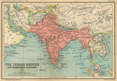
From the arrival of the Portuguese explorer Vasco Da Gama on the shores of western India in the 15th Century to establish links with spice traders, and the later arrival of the British East India Company in Bengal, the beginnings of the extensive trade links with India we see today, were established. Today India is renowned for its rapid development and the growth of its high tech industries and is increasingly attractive to foreign investment. It is home to a diverse population of over one billion people and is the worlds largest democracy.
However the country has undergone many changes to become the nation it is today, most notably the alteration of its territory during the quest for independence in the 1940s which lead to the creation of the modern day countries of India, Pakistan and Bangladesh. The changes implemented during this particularly turbulent period are still felt today and have altered the social dynamics and geography of the country.
Key questions
Why was the 60th anniversary of the partition of India and Pakistan marked in the UK in 2007?
What was the relationship between the British and the Punjab?
What can different sources tell us about partition?
What are the views on partition by people today?
Factsheets
These fact sheets provide background information to each of the key questions. They can be used together with the associated downloadable activities to investigate each area.
Downloadable activities
The downloadable activities used with the associated factsheets can be used in the classroom to investigate each area.
An education pack exploring the Punjab and its past has recently been developed. The pack entitled Pictures of the Punjab contains activities for students from the ages of eight to 12 and can be downloaded in sections.
The Society's exhbition The Punjab: Moving Journeys explores the complex history of the Punjab region, spanning India and Pakistan, and the impact of migration by successive generations of Punjabi people. The exhibition reveals the reasons for migration, regionally and internationally, from the late 1800s onwards. The contemporary significance of these journeys is revealed through the perspectives of UK-based community groups with links to the Punjab in both countries.
Links
-
Foreign and Commonwealth Office: find out more about India and Pakistan from the FCOs country profiles
-
United Nations Statistics Division: discover detailed statistics exploring the human and physical geography of India and Pakistan
-
National Geographic: discover detailed maps of territories including the Punjab, suitable for use by teachers
-
BBC World News: a short video clip giving an overview of the events leading to and the main historical figures involved in the decision to partition India in 1947
-
Royal Geographical Society (with IBG) Image Library: search through the Societys extensive collection of historical and modern images
-
BBC News Channel: maps of India pre and post-partition
-
Oral History Society: obtain guidance on conducting oral history interviews
This theme was developed with support from the UK Punjab Heritage Association, the Muslim Womens Welfare Association, Cartwright Hall Young Ambassadors and the North Hertfordshire Sikh Education Council. Workshops were conducted with these groups exploring some of the themes raised within these resources.


