Water sources in Oman
Aim and introduction
Oman is an arid country in the Middle East. Freshwater is limited to areas of high elevation, in the northern and southern extremities of the country. Oman, therefore, relies on aquifers, in the Dhofar (Najd), Al Dahra (Al Massrat) and Sharqia (Rimal al Sharqia) regions, and the process of desalination. Desalination makes an important contribution to Oman’s water resources, particularly in areas which lack reliable access to water. Desalinised water, as a share of the overall country’s water budget, is therefore increasing. This lesson aims to look at the different water sources in Oman and how these can cause potential water stress.
This lesson will take between 45 and 60 minutes.
Curriculum links
Key Stage 5 curriculum: physical geography, including: climate zones, biomes and vegetation belts, rivers, mountains, volcanoes and earthquakes, and the water cycle. Specifically:
AQA 3.1.2.1 Deserts as natural systems. Characteristics of hot desert environments and their margins: climate, soils and vegetation (and their interaction). Water balance and aridity index.
Edexcel Topic 5: The Water Cycle and Water Insecurity. 5.9 There are different approaches to managing water supply, some more sustainable than others.
OCR 1.1.3 Option C – Dryland Landscapes. Dryland landscapes are influenced by a range of physical factors: climate, including precipitation totals and patterns, geology, and latitude and altitude.
WJEC 3.1: Water and Carbon Cycles. 3.1.5 Deficit within the water cycle.
Learning goals
1. Know what desalination is.
2. Describe the physical context of Oman, in particular the arid climate of the country.
3. Evaluate the policies and management strategies Oman employs to ensure reliable water supply.
Learning outcomes
Expected level: Students will describe the geographical context of Oman. They will explain why there is a need for desalination. They will annotate a diagram of the desalination process, illustrating how seawater is converted into portable water. They will use specific examples from Oman, like the Barka desalination plant near Muscat.
Working towards: Students will describe the geographical context of Oman. They should be able to explain why there is a need for desalination. They will annotate a diagram of the desalination process.
Key terms
Desalination
The process of removing salt and other impurities from seawater to produce fresh water suitable for human consumption, irrigation, and industrial use.
Climate change
The significant and lasting changes in the Earth's climate, particularly an increase in average global temperatures, extreme weather events, and water stress.
Wadi
An Arabic word for valley, typically describing dry riverbeds across the Middle East and North Africa. Some valleys contain seasonal rivers during the rainy season.
Learning resources
If you wish to use the online atlas, The Geography Visualiser, this lesson will require access to the internet. Some of the hyperlinks connect to YouTube. The Main 1 – water stress section asks students to create a graph in Excel.
Challenge and support
To challenge students read this document and follow the Ask students subheadings. This lesson contains activities on ArcGIS maps, graph drawing in Excel, and higher-order questions.
To support students consider reducing the data to 10-year intervals, part-complete the Excel graph to aid completion, and annotate some of the desalination diagram.
Starter
Class discussion on water scarcity. Some questions to consider:
As an opening question, ask students to discuss what the main sources of freshwater are. Glaciers, ice caps, and groundwater.
Ask students to describe the geographical context of Oman, either by using a paper atlas or the ArcGIS Geography Visualiser. Then use the images to describe the landscape in Oman with a follow up question: Why is water scarcity a significant issue in some regions of Oman? Climate change, population growth, and agricultural demand are all causes of water scarcity in Oman.
Present students with the 3 data tables covering population, annual average temperature, average precipitation, and freshwater withdrawals for Oman. Questions to ask students could include:
Is Oman's population increasing or decreasing?
What is the trend in annual average temperatures?
Which biome best describes Oman according to The Five Major Types of Biomes?
Why might the annual freshwater withdrawal data be concerning?
Main 1 – water stress
Precipitation
Using the data in the PowerPoint for 1970, 1990, 2010 and 2030, ask students:
To create a stacked column chart to represent the major annual sources of water in Oman for the years 1970, 1990, 2010, and 2030 (a model data representation is shown in the lesson plan document).
Analyse how water sources in Oman changed over time.
Present information about geology, aquifers and altitude then get students to work together to answer the following questions using the Oman elevation map:
What is the highest point in Oman, and what is its elevation?
Describe the variation in elevation across Oman, from its lowest to highest points.
How does the altitude of the Hajar Mountains influence the climate and vegetation in Oman?
Main 2 – Desalination
Begin with students watching How desalination plants keep water flowing in Oman. Ask students:
To define desalination.
Why does Oman rely on desalinated water?
How many desalination plants are there?
What are the costs?
Present the diagram of a desalination unit, students to annotate the 11 steps onto a copy of the desalination plant diagram.
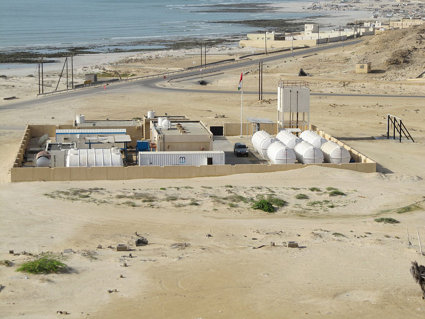
Plenary – Sharqiyah desalination plant in Al-Bar, Sur
Present information about the Sharqiyah desalination plant, students create a mini-case study on for their notes.
As a reflection / extended learning task, students could:
Research the 5 major aquifer systems in Oman to explore how aquifers are an alternative water source.
Plan the answer to the following examination style question ‘Evaluate the environmental, economic, and social impacts of desalination as a water supply solution in Oman’.
File nameFiles
File type
Size
Download