This module, comprising five lessons, or half a term's work, focuses on Rivers. Pupils will learn that rivers and river systems, are dynamic; changing the landscape in visible and at times dramatic ways. While only a fraction of the world’s fresh water is visible in lakes and rivers, river systems can have a fundamental impact on peoples’ lives.
Pupils begin by examining a model river system, following the journey of a river through its upper, middle and lower course; from its source in the mountains, through the meanders of flatter land, to the estuary and its mouth. They will also understand the process of flooding and why and how rivers breach their banks. Using a case study of a recent flood events in the UK, pupils then see the causes and consequences of flooding in real life and how flooding effects both people and places.
In the third and fourth lessons, the focus will move to the River Thames; the UK’s second longest, but arguably most iconic river. In the third lesson, pupils will understand the geographical location of the main rivers in the UK. Then, looking closely at three OS map extracts at different points along the River Thames, pupils develop their map skills undertaking a range of tasks. These mapping activities will also highlight the physical features of the river system and ask pupils for evidence of how the use of the River Thames has changed over time. As a homework activity, pupils will be asked to locate the main rivers in each of the world’s seven continents. In the fourth lesson, the characteristics of the river and surrounding landscape, at different points along its course will be located and examined. The role of the Thames Flood Barrier, one of the largest movable flood barriers in the world, will also be highlighted.
In the fifth lesson, the focus turns to North and South America, as well as England’s highest unbroken waterfall. Pupils will learn about the structure and formation of waterfalls. Using case studies of the Niagara Falls on the US/Canadian border and the Angel Falls in Venezuela, pupils will understand more about the physical and human geography of these spectacular river features. Gaping Gill, England’s highest unbroken waterfall will also be featured. Locational knowledge of the major rivers in each continent will be covered in this lesson.
As a close to the module, pupils are encouraged to gain first-hand experience of a river through conducting fieldwork at a local river. Fieldwork is a key component of the National Curriculum. Seeing the features of a river in a real life context is also invaluable for pupil understanding. Recognising key features, asking geographical questions of their own environment, and looking for evidence can only make for better geographers.
What all lessons in the module have in common is a desire to make geography exciting and stimulating and based on real places. In addition the emphasis throughout is ensuring that, as teachers, we use the correct vocabulary when explaining processes geographically, reinforce locational and place knowledge and, likewise, expect our pupils to do the same.
Journey of a River
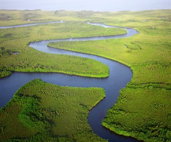
In this lesson, pupils will understand how rivers are formed. In outlining a model of a river system, pupils will understand that the features of a river and the surrounding landscape change from source to mouth. Using photographs pupils will learn that the upper course of a river is characterised by steep land, turbulent water and V shaped river valleys. In the middle course, land is flatter and rivers widen and begin to meander. Looking in more depth at key physical processes, pupils will gain an understanding of erosion, transportation and deposition and the role these processes play in shaping the river. The formation of oxbow lakes will also be discussed. Finally, pupils will learn that, in the lower course, rivers are often at their widest and have the potential to form deltas.
Flooding
In lesson two, pupils will understand the theory of flooding; why and how rivers succumb to overbank flow. Rivers flood for many reasons: in response to heavy or prolonged rainfall, due to the topography of the landscape, and morphology of rocks and soils. Human activity also plays its part; with growing urbanisation often comes an increased likelihood of flooding. By examining a case study of flood events in the UK, the 2007 floods in Gloucestershire in which the River Severn and River Avon burst their banks, pupils will also recognise that flooding has both an immediate impact on the physical environment, but also significantly impacts the surrounding community.
Mapping the River Thames
Pupils will begin by locating the UK’s major rivers before studying, in detail, the River Thames, which is the UK’s second longest river. From its source on the outskirts of the village of Kemble at Thames Head in Gloucestershire, the River Thames flows through 346 km of South East England, before joining the North Sea, at its mouth at the Thames Estuary in Essex. This lesson will investigate the characteristics of the river and its surrounding landscape. It will also highlight the changing nature of human interaction with the river. Pupils will also understand why the River Thames is liable to flooding and the measures put in place to advert a major incident.
The River Thames
In the fourth lesson, the River Thames will again be the focus of geographical enquiry. Pupils will use three Ordnance Survey map extracts to investigate the features of the river and surrounding landscape; both rural and urban. They will gain an understanding of how topography is shown on a map. In a mapping task, pupils will learn the significance of keys, contour lines, four figure and six figure grid references, grid squares, distance, scale and direction as they answer questions and interrogate evidence.
Waterfalls
Waterfalls are arguably the most impressive of the all features of a river. Pupils will understand how waterfalls are formed and their key characteristics. Three different waterfalls will then be located and investigated. Firstly the Niagara Falls in North America, which is not one, but in fact three different waterfalls; situated on the Niagara River flowing north from Lake Erie in the United States to Lake Ontario in Canada. Secondly, the Angel Falls in South America, located in Canaima National Park, Venezuela. The Angel Falls, at 979 metres high, is the highest uninterrupted waterfall in the world. Finally, Gaping Gill in North Yorkshire, at 100 metres is England’s highest uninterrupted waterfall. The uses made of these waterfalls from hydroelectric power to tourism will also be investigated.
About the author
Following a research career, Anna Brace re-trained as a teacher and taught for 7 years at Grange Park Primary School, Enfield. She was a representative on the Rediscovering London’s Geography project and coordinated the Royal Geographical Society’s Enfield CPD network for primary geography. In 2015 Anna became Head of Geography at Keble Prep School where she teaches Senior School geography to pupils in Year 5 to Year 8. She is involved in the RGS/IAPS project, London: A Subject Hub for Geography, and is also coordinating the Enfield CPD network for teachers both in the Independent and Maintained sectors.
This resource has been developed as part of the Rediscovering London's Geography project, funded by the GLA through the London Schools Excellence Fund. It seeks to improve the quality of teaching and learning of geography in London’s schools, in addition to encouraging more pupils to study geography